- Home |
- Why With Us |
- About Us |
- Booking |
- Contact Us |
- Site Map


Sagarmatha National Park
 Sagarmatha National Park is a protected area in the Himalayas of eastern Nepal containing the southern half of Mount Everest. Established in the year 1979 it was inscribed as a Natural World Heritage Site in 1979.
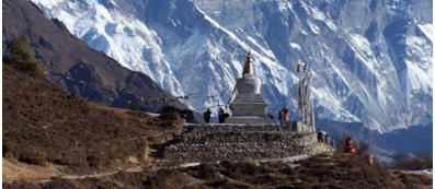
The Sagarmatha National Park includes the highest point of the Earth's surface, Mount Everest (Sagarmatha). The park is also of major religious and cultural significance in Nepal as it abounds in holy places such as the Thyangboche and also is the homeland of the Sherpas whose way of life is unique, compared with other high-altitude dwellers.
The park encompasses the upper catchments of the Dudh Kosi River system, which is fan-shaped and forms a distinct geographical unit enclosed on all sides by high mountain ranges. The northern boundary is defined by the main divide of the Great Himalayan Range, which follows the international border with the Tibetan Autonomous Region of China. In the south, the boundary extends almost as far as Monjo.
This is a dramatic area of high, geologically young mountains and glaciers. The deeply-incised valleys cut through sedimentary rocks and underlying granites to drain southwards into theDudh Kosi and its tributaries, which form part of the Ganges River system. The upper catchments of these rivers are fed by glaciers at the head of four main valleys, Chhukhung, Khumbu, Gokyo and Nangpa La. Lakes occur in the upper reaches, notably in the Gokyo Valley, where a number are impounded by the lateral moraine of the Ngozumpa Glacier (at 20 km the longest glacier in the park). There are seven peaks over 7,000 m. The mountains have a granite core flanked by metamorphosed sediments and owe their dominating height to two consecutive phases of upthrust. The main uplift occurred during human history, some 500,000-800,000 years ago. Evidence indicates that the uplift is still continuing at a slower rate, but natural erosion processes counteract this to an unknown degree.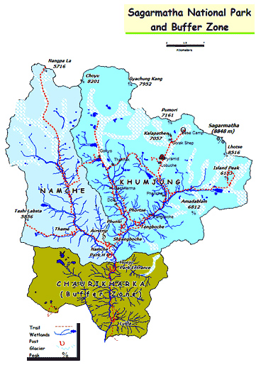
In the region there are six altitudinal vegetation classed, from oak forests at the lowest elevations to lichens and mosses at the highest elevations. The Himalayan zone provides the barrier between the Palaearctic realm and the Indomalayan realm.
Most of the park (69%) comprises barren land above 5,000 m, 28% is grazing land and about 3% is forested. Six of the 11 vegetation zones in the Nepal Himalaya are represented in the park: lower subalpine; upper subalpine; lower alpine; upper alpine; and subnival zone. Oak used to be the dominant species in the upper montane zone but former stands of this species.
In common with the rest of the Nepal Himalaya, the park has a comparatively low number of mammalian species, apparently due to the geologically recent origin of the Himalaya and other evolutionary factors. The low density of mammal populations is almost certainly the result of human activities. Larger mammals include common langur, jackal, a small number of wolf, Himalayan black bear, red panda, yellow-throated marten, Himalayan weasel, masked palm civet, snow leopard, Himalayan musk deer, Indian muntjac, serow, Himalayan tahr and goral. Sambar has also been recorded. Smaller mammals include short-tailed mol, Tibetan water shrew, Himalayan water shrew; marmot, woolly hare, rat and house mouse.
Inskipp lists 152 species of bird, 36 of which are breeding species for which Nepal may hold internationally significant populations. The park is important for a number of species breeding at high altitudes. The park's small lakes, especially those at Gokyo, are used as staging points for migrants. A total of six amphibians and seven reptiles occur or probably occur in the park.
The Sherpas
There are approximately 2,500 Sherpa people living within the park. The people are primarily Tibetan Buddhists. Their activities are primarily agricultural or trade based. Their properties have been excluded from the park by legal definition. There is and will continue to be an influence on the people by the park and vice versa. The Sherpas are of great cultural interest, having originated from Salmo Gang in the eastern Tibetan province of Kham, some 2,000 km from their present homeland. They probably left their original home in the late 1400s or early 1500s, to escape political and military pressures, and later crossed the Nangpa La into Nepal in the early 1530s. They separated into two groups, some settling in Khumbu and others proceeding to Solu. The two clans (Minyagpa and Thimmi) remaining in Khumbu are divided into 12 subclans. Both the population and the growth of the monasteries took a dramatic upturn soon after that time. The Sherpas belong to the Nyingmapa sect of Tibetan Buddhism, which was founded by the revered Guru Rimpoche who was legendarily born of a lotus in the middle of a lake. There are several monasteries in the park, the most important being Tengboche.
Buffer Zone
Government of Nepal has declared a buffer zone in and around the park in 2002 with the objective of reducing biotic pressure in the slow growing vegetation. The government has also made a provision of plowing back 30 - 50 percent the revenue earned by the park to community development activities in the buffers zone. In collaboration with local communities it aims to conserve biodiversity in the region.
Flora and fauna
In the lower forested zone, birch, juniper, blue pines, firs, bamboo and rhododendron grow. Above this zone all vegetation are found to be dwarf or shrubs. As the altitude increases, plant life is restricted to lichens and mosses. Plants cease to grow at about 5,750 metres (18,860 ft), because this is the permanent snow line in the Himalayas. 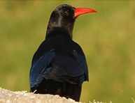
Forests of pine and hemlock cover the lower elevations of the national park. At elevations of around 3.500 meters and above, forests of silver fir, birch, rhododendron and juniper trees are found. The forests provide habitat to at least 118 species of birds, including Himalayan Monal, Blood pheasant, Red-billed chough, and yellow-billed chough. Sagarmāthā National Park is also home to a number of rare mammal species, including musk deer, snow leopard, Himalayan black bear and red panda. Himalayan thars, langur monkeys, martens and Himalayan wolves are also found in the park.
The partial pressure of oxygen falls with altitude. Therefore, the animals that are found here are adapted to living on less oxygen and cold temperatures. They have thick coats to retain body heat. Some of them have shortened limbs to prevent loss of body heat. The Himalayan bears go into hibernation in caves during the winter when there is no food available.
Seasons:
The summer climate is cool and wet and winter is cold and dry. Almost all of the annual precipitation, averaging less than 1000 mm, falls during the summer monsoon, from end of May to September. Climatically, the best time to visit the park is between October and May, except for December to February when, daytime temperatures often drop below 0 C and there is heavy snowfall.
Important Points:
- There are trekker lodges with food available in places like Namche Bazaar, Thyangboche, Pheriche and Lobuche and along most of the main trekking routes the small villages have basic accommodation.
- There is the Himalayan Rescue Association (HRA) at Pheriche which has medical facilities and also accepts credit card as payment.
- The National Park ranges from 3000 m to 8000 m and above in altitude. Visitors need to be careful and aware of High Altitude sickness (HAS). Do not climb to fast or too high in one day, no more than 400 m in a day. Signs of HAS include: headache, difficulty in sleeping, breathlessness, loss of appetite, nauseousness and general tiredness.
Popular Trekking Region:
The trek from Namche to Kala Pathar is very popular. The Gokyo Lake and Chukung valleys also provide spectacular views. The Thame Valley is popular for Sherpa culture while Phortse is famous for wildlife viewing. There are some high passes worth crossing over. However, the trekkers must have a guide and proper equipment for the trek.
Entry Fees into Sagarmatha (Everest) National Park:
At Monjo there is the Sagarmatha National Park entrance station where you will have to show your passport and pay a National Park fee which is as follows:
- For Nepali Nationals Free
- For SAARC Nationals Rs 100
- For Foreign Nationals Rs1000
- Children under 10 years Free
How to Get There:
The most common ways to reach the park from Kathmandu are:
- Flight to Lukia and two day's walk
- Bus to Jiri and 10 day's walk
- Flight to Tumlingtar and 10 day's walk
- Flignt to Phaplu and 5 day's walk
Entry Fees into Sagarmatha (Everest) National Park:
At Monjo there is the Sagarmatha National Park enterance station where you will have to show your passport and pay a National Park fee.
- For Nepali Nationals Free
- For SAARC Nationals Rs 100
- For Foreign Nationals Rs1000
- Children under 10 years Free

National Parks

Wildlife Reserve