- Home |
- Why With Us |
- About Us |
- Booking |
- Contact Us |
- Site Map


Charikot - Barabise Trekking
Days from
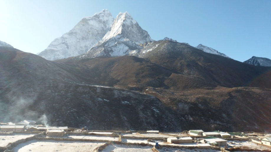
The Rolwaling valley is celebrated as one of the seven hidden valleys of the Himalayas. Often portrayed as the Beyul of mid -east horizon, it lays just south of the Tibetan boarder, and runs east to west just below Mt. Gauri Shankar (7145m). This journey takes us through some of the most pristine scenery, amidst the dazzling Sherpa and Tamang communities whose tradition remains intact till this date.
| Max. Elevation : 4600m | Duration : 17 days |
| Type of trek : Camping | Starting point : Charikot |
| Ending point : Barabise | Best Season : Spring and autumn |
| Grade : Moderate-Strenuous | : |
The Rolwaling Himal is a relatively small mountain range, about one hundred kilometers northeast of Kathmandu yet the valley (Rolwaling) itself is celebrated as one of the seven hidden valleys in the Himalayas. A not too heavy, fairly long trek to the Rolwaling valley, with many villages, a Sherpa Tamang population and surprising views of the Himalayas. On the way back we visit the Buddhist monastery Bigu Gompa and cross Tinsang LA to Barabise.
After the bus trip to Charikot we descend to the Bhote Kosi River, which we will follow. From Chetchet we climb to Simigaon, the first village in the Rolwaling valley. In Beding or Na we have a resting day which we can use to visit the Buddhist monastery or walk to the Tsho Rolpa glacier lake. On the way back through the beautiful Thar Tamangdorp we cross a ridge and reach the beautiful women monastery Bigu Gompa. The route follows a path through vast forests with langoer monkeys and friendly villages up to Tinsang La. On the pass we have a view of the magnificent Rolwaling Himal, with the Gauri Shankar (7145 m). The descent leads to Barabise, where the bus waits for the return to Kathmandu.
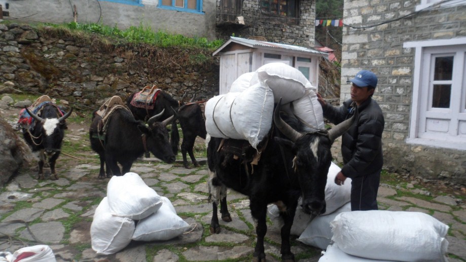
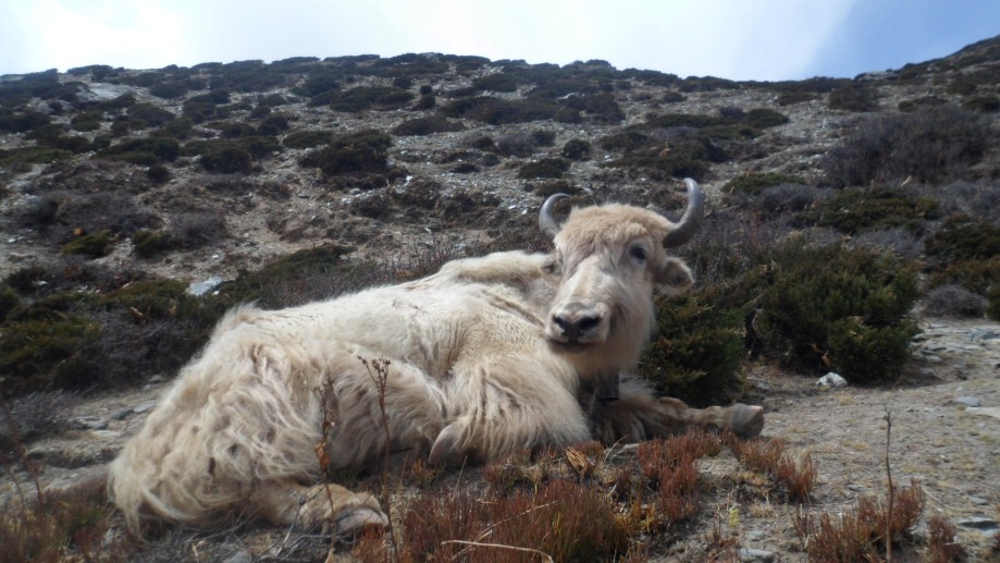
The population of the Rolwaling Valley consists almost entirely of Sherpa and Tamangs.
Day 01: Arrive Kathmandu International Airport- T I A (1300m) and transfer to hotel- The Thamel Eco Resort.
Day 02: After breakfast we set out for an extensive guided sightseeing tour of Kathmandu valleys cultural, historical, religious (world heritage) sites. During the course, we visit the famous Pashupatinath temple of Lord Shiva situated at the holy bank of River Bagmati where we will also observe the Hindu cremation ritual. We then proceed to the Boudhanath stupa, a major pilgrimage centre for the Buddhist faith which also is the largest of its kind in the world. We then have a short break for lunch followed by a visit to Swoyambhunath stupa also known as the Monkey Temple from where we can have a bird’s eye view of whole of Kathmandu valley. Following this we then proceed for a visit to Kathmandu Durbar Square, the oldest royal palace of Kathmandu and a UNESCO world heritage site. The whole area of Kathmandu Durbar Square is dotted with numerous fascinating Nepalese architect dating back many centuries. The site is also the home to Nepal’s living Goddess – Kumari, where we will also have the opportunity to experience firsthand this unique Nepali tradition. In the evening we will attend the welcome dinner hosted by Makalu Adventure with live Nepalese culture show.
Day 03: Kathmandu - Charikot - Dolakha (1700m) 7 hrs- Malephu (950m):
From Kathmandu we drive by bus along Bhaktapur on the Arniko Highway and along the Sun Kosi (river Kosi =) through the market town of Charikot to Dolakha (1700 meters). It is a nice village with the Hindu temple Dholakha Bhimsen and overlooking the holy Gauri Shankar (7145 meters).
From here we descend 950 meters to our campsite Malephu / Rato Mate (= red clay) near the Dolti Khola, which joins the Bhote Kosi a little bit further. The descent to the river is beautiful, occasionally using a staircase made of clay and stone blocks. We pass through many villages. At the river the first suspension bridge will be crossed. After the suspension bridge is the beautiful camping site. It is possible to swim in the river.
Day 04: Malephu - Sangawa Khola (1000m) 5 hrs:
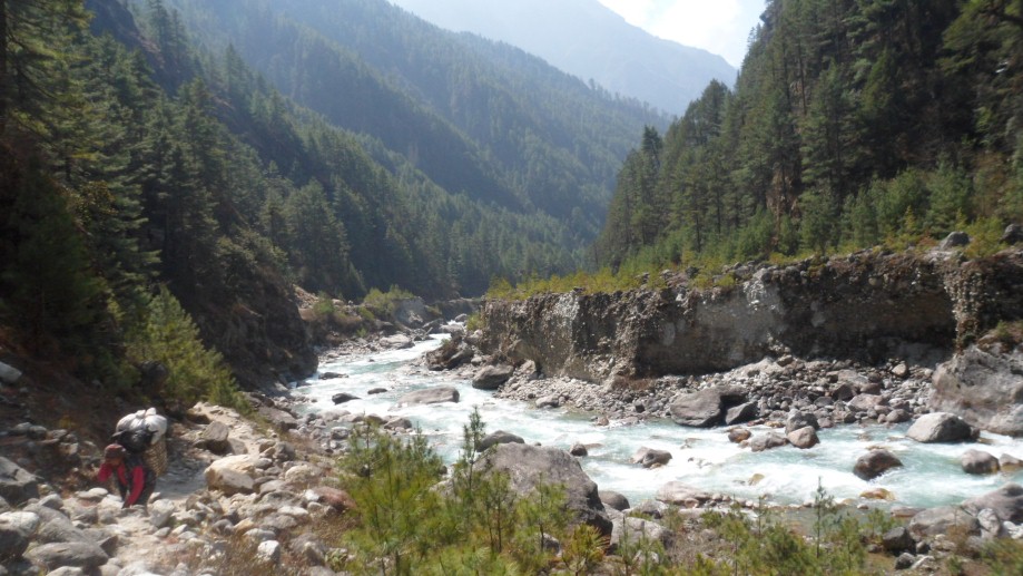
After the wake-up call with tea and washing water we set off for the first walking day. We follow the beautiful woods on the west bank of the Bhote Koshi (= river in Tibet), which is sometimes called Tama Koshi. The mountain slopes are not steep and villages, rice terraces, and forests complete the friendly character of the valley. We lunch on the banks of the Gumbu Khola, another tributary of the Bhote Koshi, near the village Biguti. Biguti is a nice village where merchandise is displayed on the street.
Just before Shigati we pass the office of the Development Eco Himal Project. This is an Austro-Nepalese project for development in this area. With clear weather, the very striking Gauri Shankar can be seen. When we get higher during the trip we can also see the other Rolwaling summits. After the suspension bridge at Shigati over the tributary Sangawa Khola we leave the valley (which runs into Tibet) and follow the path in a northwest direction to the camp site on the banks of the Sangawa Khola.
Day 05: Sangawa Khola – Gongar Khola (1300m,) 6 hrs:
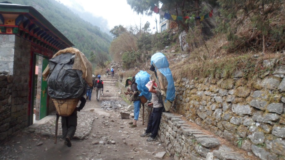
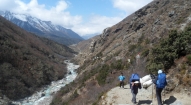
From Shigati we walk in just over an hour to Suridobhan. It remains a beautiful walk between rice fields and typical Nepalese villages with local “walking traffic”. We cross many rivers over different types of suspension bridges. During the tour, there is ample opportunity to look around in the villages. After Suridobhan, now on the east bank of the river, the valley narrows. Although the path is good, we have to be careful. Halfway between Suridobhan and Jagat we have our lunch.
In the afternoon, the valley is becoming rougher; the path is significantly rising and falling along the western bank to Jagat, where there are a dozen isolated houses. About a half hour past Jagat we get to Gongar. We camp just outside the village, near the Gongar Khola.
Day 06: Gongar Khola – Simigaon (2100m) 4 hrs:
This is a relatively short day, but with a considerable climb. First we follow a part of the Bhote Kosi, until we reach Chetchet and cross another suspension bridge on the eastern shore and start the steep, 2-hour climb from the valley of the Bhote Kosi to the Rolwaling Valley. Reaching the first houses of Simigaon means that we are still far from the camp site near the school. We must show our permits at the check post. Simigaon is a multicultural village: on the lower slopes mainly Tamangs are living, while the Sherpas are mainly living on the higher slopes. The Buddhist gompa which overlooks the village is the religious center for both populations.
Day 07: Simigaon - Dong Gang (2700m) 5 hrs:
Today is a great day through mountain forests full of rhododendrons, in the full blossom in spring. We follow a path that's cut out of the rocks. From the threshold of the Rolwaling valley we descend to the Rolwaling Chhu (= river, 2000m). Here begins an easy climb of 2 hours to Gyalzen (2800m). Halfway we stop for an early lunch.
After an hour of mostly descending, we come to Dong Gang. The camp is located on a terrace above the river, next to PEMA's Tea Shop. Only part of the year people live here, because in the monsoon period (June-September) the Rolwaling Chhu overflows the area. The roaring river and the high, almost vertical walls on the northern side of the valley make Dong Gang an impressive camp spot.
Day 08: Dong Gang – Beding (3700m) 5 hrs:
Due to the height of more than 3000 meters and the altitude differences of today we walk in quiet pace.
After about 1 ½ hours through pine forest we reach the 'proud' of Rolwaling Valley: the Naya Pul (= bridge) over the Rolwaling Chhu, which was built with Swiss assistance. Shortly after, we cross over a tributary via a very old and primitive suspension bridge with loose and missing boards. In the north lies the beautiful Gauri Shankar. The path rises to a solitary hut with stunning views over the valley towards Simigaon. At a holy place are Buddhist prayer flags and three teeth of the Hindu god Shiva. This illustrates that the two religions in this country go hand in hand. About an hour before we arrive in Beding, we walk through the villages Nyimare, Ramding and Gyabluk, which more or less are connected with each other. In Beding we camp along the river on a lawn with lots of loose stones.
Day 09: Beding
We take a rest in Beding for the necessary height adjustment. In any case it is worth it to visit the gompa. On the rocks directly above Beding is a second sanctuary with a magnificent view over the valley.
Day 10: Beding – Gaon (4200m) 4 hours
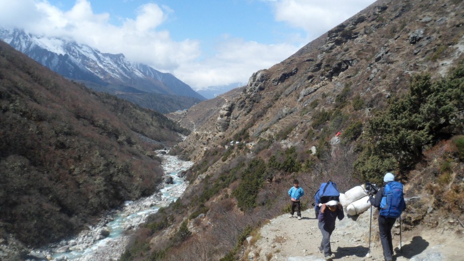
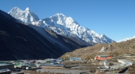
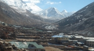
Today we walk to the summer village Gaon and get over 4000m. The pace continues to be on the low side! Above Beding grows only low scrub, the mountain views are completely free. The path rises gradually, without long steep passages. We pass the shepherd settlement Dokare. Na Gaon broadens the valley and we get beautiful views of the surrounding mountains: the Nachugo Kang (6700m), the Chobutse (6700m), the Drakar Go, and in the south, the granite walls of the Yab Yum (!). In the east we discover even mountains on the border of the Rolwaling and Solu Khumbu (the Everest region), far behind the Tsho Rolpa glacier lake. We see huge moraine ridges.
Day 11: Gaon
Rest day or a day trip up the valley. We may, for example, walk to the Tsho Rolpa Lake or even higher to Omai Tsho in a side valley. The Tsho Rolpa is a natural reservoir behind an old moraine. The higher we are, the more impressive the views of the surrounding mountains are.
Day 12: Gaon - Dong Gang (2700m) 6 hours:
From Gaon we walk back the same route we came. Still, there is plenty to see, because we experience the environment in a very different way. We mainly descend. Moreover, we have become accustomed to the height and can easily and smoothly descend to Dong Gang.
Day 13: Dong Gang - Gongar Khola (1300m) 5 hours
Today we descend another 1,400 meters over 'known' paths to Gongar Khola.
Day 14: Gongar Khola- Gyalsung Danda (2300m) 6 hours:
The following two stages lead further to the west over the Gyalsung Danda (Danda = ridge). As we get higher, the heat and humidity of the deep valley of the Bhote Koshi makes place for fresh air on the mountain slope. The path leads between many rice terraces to Thar. After we have climbed more than 1000 meters, we reach our camp spot. A beautiful grassy plain, albeit slightly sloping! Opposite us we see the entrance of the Rolwaling valley with Simigaon and far above, the mighty Gauri Shankar.
Day 15: Gyalsung Danda – Bulukpa (2500m) 7 hours:
Above Thar we climb over the Mane Danda to Gyalsung Danda. As we get higher, the ridge is covered with rhododendron. Between the trees, the views to the east remain imposing. After about 3 hours climbing, we reach the ridge lunch spot, a clearing in the forest with a few huts. Depending on the season we would consider at this point whether water is present or if we should descend until we reach a stream.
The afternoon stage is almost entirely downhill and leads through a beautiful mixed forest. We descend a bit over the Gyalsung Danda to the south, until the path bends westward towards Bulukpa, a settlement of a small number of isolated houses with a Gompa. We camp on the lawn next to the gompa.
Day 16: Bulukpa -Bigu Gompa (2600m) 6 hours:
A short day that brings us over an excellent path through a lovely environment to Khartali. As we come closer to this village, the area changes into increasingly large millet terrace. Here and there are beautiful Sherpa houses. Between the wet terraces the path is sometimes slippery. We lunch near the Alamphu Khola, the lowest point (1850m) of today. In the afternoon we have a fairly steep climb, again along millet terraces to Bigu Gompa, where we will stay the next 2 nights.
Day 17: Bigu Gompa
Bigu Gompa is a woman monastery where about 35 nuns practice Buddhism. The afternoon can be used to visit the women's monastery. The nuns appreciate it when visitors show up. It is also possible to attend a service (3x per day). This is an impressive experience. The sound of the long trumpets, horns, flutes and drums shell and the reading of the mantras will not be forgotten soon.
Day 18: Bigu Gompa - Tinsang La (3000m) 5 hours:
We walk over area with many chortens and descend stone stairs, through rice, millet and corn fields to the suspension bridge over the Amatal Khola. We cross a tributary and begin the two days climb to the Tinsang La, the last climb of the trail.
At noon, the path leading through the woods comes to an open spot. At this kharka, just east of La Tinsang, we set the tents up and hope for a bright night! A golden rule is often: "How crisper night, the fewer clouds in the morning".
Day 19: Tinsang La - Dholangse (2400m) 5 hours:
If the weather is clear we are on our way, and from the Tinsang LA we see a truly breathtaking view of the mountains north and east of us. From the striking Ama Bamare via the Gauri Shankar till the pointy Numbur. In the West we recognize the hills surrounding the Kathmandu Valley. On the west side of the Tinsang La the path is dropping steeply and on a very erodible slope it can be difficult. After about 300 meters the path is improving. On a similar kharka, we have lunch. After lunch we walk on a better path to the camp site at Dholangse with its gompa and its former paper factories. In the evening we hand our staff their tip and drink and sing with them to celebrate the trip.
Day 20: Dholangse – Barabise (900m) – Kathmandu 6+4 hours:
After a final wake up call, we pack our stuff. Beyond the gompa of Dholangse we walk to the west over two mountain ridges and cross two tributaries of the Sun Koshi. In Pading there is a beautiful bridge and a high waterfall. We lunch in a rice field with 3 mills. After lunch we walk along villages and rice paddies to the Batas Danda (Danda = ridge) and descend over steep stairs between a rice farming village to Barabise. Our bus to Kathmandu is already waiting and in 4 hours we are back in crazy Kathmandu.
Day 21: Day at complete leisure at Kathmandu followed by few rounds of Snoker over some drinks in the evening.
Day 22: A day in Kathmandu, with a guided sightseeing tour of the city's main remaining attractions which were not covered during our initial sightseeing. This will include visits to Patan and Bhaktapur followed by farewell dinner in the evening hosted by Makalu Adventure. Overnight at Thamel Eco Resort.
Day 23: Final Departure.
Should you prefer a different route or itinerary for this program, just let us know your interests and we will be more than happy to craft a tailor made trip for you in line with your specific preference.

- All airport/hotel transfers
- All accommodation in Kathmandu (including breakfast and all taxes).
- Welcome and farewell dinner
- All accommodation and meals during the trek
- Domestic flights (if and where stated on the itinerary)
- Trek leader, assistant trek leader) Sherpa porters including their salary, insurance, equipment, flight, food and lodging
- Down jacket, sleeping bags, Trekking kit bag/duffel bag, trekking map and trekking Poles
- All necessary paper work and permits (National Park permits or entrance fees etc if required)
- A comprehensive medical kit
- All government and local taxes
- Nepal visa fee
- Airport departure tax
- International airfare to and from Kathmandu
- Excess baggage charges
- Lunch and evening meals in Kathmandu and in Pokhara
- Extra night accommodation
- Travel and rescue insurance
- Personal expenses (phone calls, laundry, bar bills, battery recharge, extra porters, bottle or boiled water, showers etc)
- Tips for guides and porters