- Home |
- Why With Us |
- About Us |
- Booking |
- Contact Us |
- Site Map


Manaslu, Tilicho Pass & Upper Mustang
Days from
This is a part of the Great Himalaya Trail - GHT - a new route linking the high, Himalayan trails from the Far East to the far west of Nepal (and soon including Bhutan, Tibet and Pakistan). You can now join us for this epic journey which begins in Gorkha, the old capital of Nepal. We take the more remote \'high\' route around Manaslu via the Larkya La, afterwards heading to the turquoise Tilicho Lake and crossing Tilicho Pass in the central Annapurna range to reach Lower Mustang. We finish this section of the GHT with an exploratory trek through once forbidden Upper Mustang in search for ancient Tibetan Buddhist cave-gompas, intricately painted with thousand-year old murals, and the last nomads of Lo, living in the shadow of Dhaulagiri.
| Max. Elevation : 5400m | Grade : Strenuous |
| Best season : Sep-Dec&Apr-June | Type of trek : Camping Trek |
| Duration : 24 Days | Starting point : Kathmandu |
| Ending point : Kathmandu | Highlights : Nature |
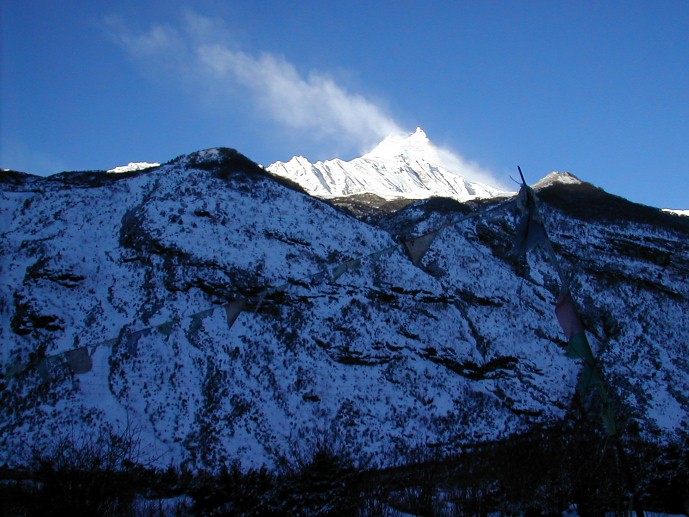
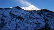
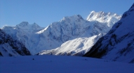
Manaslu, the 8th highest peak on the planet, locally known as the "mountain of the spirit", is one of the most spectacular snow-peaks in Nepal, and the Manaslu Circuit, officially open for trekking in the early 90s, a cultural trek par excellence, without a doubt one of the best treks in Nepal. Oddly, it's also one of the Nepal Himalaya's least known treks, and happily doesn't boast of apple-pie lodges, sprawling trekking villages, internet cafes or Western coffee shops. A trek around the 'high' Manaslu circuit is a step back in time, a glimpse of pristine Nepali and Tibetan villages, a walk through a remote Himalayan paradise. The diversity of the trek, from the Hindu middle hills to the Tibetan high-country dwellers, and the awesome mountain scenery of the Manaslu Himal and surrounding peaks combine to make this circuit one of the most interesting, as well as one of the most challenging, treks in Nepal.
HW Tilman and his team were the first mountaineering expedition to explore the region in 1950, and the Japanese the first team to climb it in 1956; since then, Manaslu has been known as a Japanese mountain, and because of its sensitive location right at the border of Tibet, few western trekkers ventured into the region.
• Mustang - the Kingdom of Lo
Formerly the Kingdom of Lo and a part of the Western Tibetan Kingdom of Ngari, 'forbidden' Mustang has lured intrepid travelers to its remote realm for centuries, but only the most adventurous made it to this mountainous and inaccessible bastion of Tibetan Buddhism. Sven Hedin, a famous Swedish explorer of over a century ago, said it was known in Tibet as "the land of the king of the south".
People have inhabited this harsh region for thousands of years, some of the early dwellers living or meditating in ancient caves, rich in Buddhist art, which pepper the bizarre rock formations. Mustang became part of the Yarlung Dynasty of central Tibet, later falling under the jurisdiction of the Malla Kingdom of Nepal (Jumla) and in the fifteenth century, the independent Kingdom of Lo was founded, ruling such other remote regions as Dolpo, which sent its most famous mural painters to Lo to pay tribute to the King of Lo. Like in Tibet and the border regions of Nepal, you find remnants of the ancient Bon religion (demon traps which hang over doors, protective shrines on rooftops) which pre-dates Buddhism in Mustang. Buddhism is now the dominant religion and it infuses the every aspect of the lives of the Mustang-pa (people). Mustang was only incorporated into the Kingdom of Nepal in 1951. Soon afterwards, renegade Khampa freedom fighters battling the Chinese used Mustang as a base of operations, and it was closed to all Westerners until 1992.
• 15th - early 17th centuries: Mustang was called the Kingdom of Lo. Mustang then dominated the salt trade along the Kali Gandaki River bed, and throughout the Tibetan region, and was a wealthy and powerful region.
• 17th century: Mustang was forced to pay levies (taxes) to the Kingdom of Jumla and came under their extended Kingdom.
• 1795: Jumla was defeated by the Gorkhas and the Kingdom of Lo (Mustang) transferred its allegiances to Gorkha, which by then was the capital of a unified Nepal.
• 1855: Lo supported Nepal against the Tibetans. The King of Nepal thus allowed the King of Mustang to keep his title of 'Raja of Mustang’.
Birdlife
Hill and rock pigeons, crag martins, rose finches, pied wagtails, rock buntings, black redstarts, impeyan pheasants, grandala, snowcock and white-capped river chats (and many more).
Special Note: This mythical land north of the 8000 meter peaks Annapurna and Dhaulagiri still requires a special 'Restricted Area' permit to enter and numbers are limited, thus helping to preserve its unique heritage and Tibetan life-style.
Outline Itinerary
- Day 01: Kathmandu arrival (1340m)
- Day 02: Kathmandu
- Day 03: Drive Gorkha. Trek Gorkha Camp (1060m):
- Day 04: Trek Arkhol (570m)
- Day 05: Trek Kalibote, Phedi (800m)
- Day 06: Trek Barpak (1915m)
- Day 07: Trek Laprak (2200m)
- Day 08: Trek Korlebesi (875m)
- Day 09: Trek Jagat (1370m)
- Day 10: Trek Philim (1570m)
- Day 11: Trek Deng (1865m)
- Day 12: Trek to Namrung (2540m)
- Day 13: Trek to Lho (3180m)
- Day 14: Trek Sama Goan (3525m)
- Day 15: Sama Goan
- Day 16: Trek Samdo (3850m)
- Day 17: Samdo
- Day 18: Trek Dharamsala High Camp, Larkya Phedi (4460m)
- Day 19: Cross Larkya La (5140m) - trek Bimtang (3590m)
- Day 20: Trek Tilje (2300m)
- Day 21: Trek Chame
- Day 22: Trek Pisang
- Day 23: Trek Manang
- Day 24: Trek Tilicho BC
- Day 25: Trek Tilicho High Camp ( )
- Day 26: Trek Tilicho Pass Camp ( )
- Day 27: Trek Jomsom
- Day 28: Trek Kagbeni (2900m)
- Day 29: Trek Tsaile (3060m)
- Day 30: Trek to Shyangboche (3765m)
- Day 31: Trek To Dhakmar (3820m)
- Day 32: Trek to Tsarang (3575m)
- Day 33: Trek Lo Manthang (3820m)
- Day 34: Lo Manthang - Chosar & Tingkar Valleys
- Day 35: Trek to Mid-Camp
- Day 36: Trek to Chuchu Gompa
- Day 37: Trek to Nomads Camp
- Day 38: Trek to Chuchu Gompa Valley Camp
- Day 39: Trek Yara (3610m)
- Day 40: Yara (day trip to Luri Gompa0
- Day 41: Trek to Ghemi (3570m)
- Day 42: Trek to Samar (3600m)
- Day 43: Trek Tetang (3000m)
- Day 44: Trek Muktinath
- Day 45: Trek Jomsom
- Day 46: Fly Pokhara - Kathmandu
- Day 47: Kathmandu
- Day 48: Final departure
Detailed Itinerary
Day 01: Arrive Kathmandu International Airport, (1300m/4264ft) and transfer to hotel.
Day 02: After breakfast we set out for an extensive guided sightseeing tour of Kathmandu valley’s cultural, historical, religious and world heritage sites. During the course, we visit the famous Pashupatinath temple of Lord Shiva situated at the holy bank of River Bagmati where we will also observe the Hindu cremation ritual. We then proceed to the Boudhanath stupa, a major pilgrimage centre for the Buddhist faith which also is the largest of its kind in the world. We then have a short break for lunch followed by a visit to Swoyambhunath stupa also known as the Monkey Temple from where we can have a bird’s eye view of whole of Kathmandu valley. Following this we then proceed for a visit to Kathmandu Durbar Square, the oldest royal palace of Kathmandu and a UNESCO world heritage site. The whole are of Kathmandu Durbar Square is dotted with numerous fascinating Nepalese architect dating back many centuries. The site is also the home of Nepal’s living Goddess – Kumari, where we will also have the opportunity to experience firsthand this unique Nepali tradition. In the evening we will attend the welcome dinner hosted by Makalu Adventure with live Nepalese culture shows.
Day 03: Drive to Gorkha - trek Gorkha Fort Camp (1060m): After breakfast in Kathmandu, about 5 hour drive takes us to the historic town of Gorkha, the old capital or kingdom of Nepal, with its old 'durbar', or King's palace –the Gorkha Durbar at the top of the hill of Hindu deities, perched high up in the surrounding hillsides and reached by worn stone steps. After organizing the gear and loads with the porters, we head up many stone steps (about an hour to the fort) to our first night's campsite above the Gorkha Fort, stopping en route to visit this well-maintained site, home of the powerful Gorkha royalty until about a century ago. We can see the crew setting up camp from the top of the fort and it will only take us 15 minutes to reach camp, so linger at this atmospheric spot as long as you'd like. Notice the local 'saddhus' who stay at or visit the Hindu temples inside the fort.
Day 04: Trek to Arkhol (570m):
We wake to misty mountain views in the morning: the Manaslu range and the Ganesh Himal range are the dominant ones. Have a look over fresh coffee and chai! The middle hills of Nepal are timeless, and we trek for the first two days through classic middle hills scenery; rolling, forested hills, snaking rivers with rounded rock strewn on the beaches, local fishermen casting their nets, iridescent rice fields, papaya, lemon and orange trees, water buffalos, thatched huts and local 'bhattis' (Nepali tea-houses) along the trail for a quick dal bhat or cup of chai. More…
We have a hot seven-eight hour day for our first real day of trekking; with many locals selling bananas and papayas en route (bring small change). We'll meet many colorful Gurung and Hindu local en route, and will have time to stop at the many traditional villages along the way. We start by descending gradually on stone slab steps to scattered tea-houses, vivid green rice paddies and several small, densely populated village with a school right on the trail, the kids in the schools reciting their lessons. The next descent is very steep and slippery, a long drop down to a small bridge which leads us past more flooded rice-paddies to a dirt road which we walk along for half an hour before reaching a small cluster of tea-houses where we'll stop for a cup of tea. A quarter of an hour later, in the heat of the day, we reach a local bhatti, continue on past more terraced fields and through a small village and then climb up to a point overlooking a magnificent S bend in the Daraundi Khola far below. We descend back to the river and stop at a much needed swimming hole and rocky beach where we cool down and have our packed lunch. About 10 minutes past this stop is a long bridge where we can watch locals swimming and catching fish below us, and then past the village on the other side where cold cokes are available we cross a rickety, swaying, wooden bridge, perhaps the longest in the region. Ekle Sangu is the dingy village on this side of the river; there is a vegetable market just above the village where we will pick up a few supplies for dinner. Another hour and a half of dirt-road trekking on the left bank of the river and again through several small hamlets and bhattis brings us to a small, metal bridge over a small, intersecting bridge. We cross, hike another half an hour and reach our lovely campsite along the beach on the Daraundi River just below the small village of Arkhol.
Jump in the river and then enjoy our first mountain sunset. The village kids with surely be by to see what's happening, perhaps carry a basket of beer. Take advantage of a chance for a sun-downer while we're still low in altitude!
Day 05: Trek to Kalibote (800m):
A continuation of yesterday's lovely scenery and another six hour day, we trek though bustling Gurung villages, over several swaying suspension bridges spanning the river, past a high waterfall which tumbles to the trail, and back up just a bit to reach our camp at Kalibote in the early afternoon. Tomorrow we have a steep climb ahead of us, and this is the last campsite before the (large) hill. Head down to the river and perch yourselves on the smooth river rocks next to the wonderful swimming hole for a wash after our hot day if you like, and afterwards chilled beers are available from an enterprising little tea-house next to camp.
Day 06: Trek to Barpak (1915m):
After a big breakfast; we head off early to avoid the afternoon sun for our steep, long climb up to the wonderful village of Barpak, situated perfectly on a green ridge overlooking the misty valley below. It should take us under four hours to get to camp, with several chautaras (rest stops) and the lower village and lively school en route. Barpak is a large, Ghale (royalty) Gurung village, extremely clean, with a weekly market, wide alleys between the houses, grain and vegetables drying outside on the patios, several shops, viewpoints and flowers planted along the decks of these Gurung houses. Many of its men joined the Ghurkha Army, returned to Barpak with new wealth, and have built lovely houses. We arrive in time for lunch, and have the afternoon to wander the narrow streets of the village, a photographer’s paradise. The villagers often organize 'cultural shows', the proceeds of which go to improving the village, so we might be treated to one in the early evening. At Barpak, we are towered over by Bauddhi Himal, a high, snow-capped peak which makes for wonderful sunrise and sunset photos.
Day 07: Trek to Laprak (2200m):
Another early start and a picturesque climb, with Bauddhi Himal providing a spectacular back-drop to the sprawling, scenic Barpak as we ascend the narrow ridge; we take the small, stone trail to the right of the main trail after an hour or so, and a total of three hours later, we reach the ridge, officially a pass, which separates Laprak and Barpak, and are rewarded with panoramic mountain views (along with herds of sheep grazing on the grassy hillsides) from the peak. Bauddhi Himal, Shringi Himal, Ganesh Himal and the Langtang range all span the horizon; a truly breath-taking view! If the trek is done during the spring season, the rhododendrons bloom brilliantly, in many hues of pink and red, around us, providing great photographs with the snow-peaks in back! Bring a wind jacket as the clouds often move quickly up to this ridge, and it gets cold quickly.
Another steep hour or two of trekking brings us down to another large Gurung village, Laprak, perhaps not quite as scenic as Barpak but just as interesting. Here we camp in the only campsite around, at the school in the upper section of the village, with several tea-houses nearby. Again, we have the afternoon free to explore the village; take a walk down the hill and a look into some of the houses, all with symbolic murals on the mud-brick walls. The villagers are friendly, and there is lots to explore in Laprak's winding maze of lanes.
Day 08: Trek to Korlebesi (875m):
A classic Nepali trekking day of seven to eight hours, all beautiful. We descend through Laprak's maze of village paths, the villagers on their decks with their wheat, barley and buckwheat laid out on straw mats, and descend steeply to their corn, wheat and barley fields below the village, and then to the river. After crossing a very rickety suspension bridge, we climb equally steeply back up, past terraced fields of pink sorghum and rice. We contour around several hillsides on a narrow trail, barely visible at times, up to a small chorten just below the village of Singla. From here, the going is easy, and we enjoy the views of the Manaslu Himal, Kutang Himal and Shringi Himal to the north as we walk down through more terraced fields and papaya trees, through the Gurung village of Korla, and then down along a narrow, winding trail to Korlebesi on the Buri Gandaki river. Take care as the rocky steps just before the long suspension bridge to Korlebesi are treacherous! Look out for the local women weaving straw mats in the village. Our campsite is just below the village, next to a small tributary stream, again providing great swimming holes.
Day 09: Trek to Jagat (1370m):
A five hour day today, starting with an hour of walking along the river, by tobacco and buckwheat fields, past rocks washed smooth by the river, often climbing up stone steps, to reach the hot springs in the centre of the small, terraced village of Tatopani. We have plenty of time to soak our grungy bodies in the gushing hot water, and then perhaps go for a swim in the icy river below, drying off on the wonderful river-side beach. A gentle climb through the woods past some spectacular waterfalls, across an old, wooden suspension bridge and through a short section of forest path and we reach Dobhan. Above Dobhan, the Buri Gandaki descends in an impressive series of steep rapids. Here, our trail climbs high above the river to descend through what appears to be a huge gateway into some secret place; in front the valley widens, the river calms, and we cross the river on a long, new suspension bridge and climb high on stone steps before coming into our camp below Jagat, the entrance to the Manaslu park. It is worth wandering around this beautiful, paved village, where proud villagers have recorded how much they contributed to these paving schemes. Our campsite is impressively clean and grassy, with cold beers available at the shop next door.
Day 10: Trek to Philim (1570m):
A short day, enjoy it! After descending a long series of stone steps back down to the river from Jagat, we climb on wonderful stone steps along a terraced hill-side to the small hamlet of Saguleri, from where we can see the impressive Shringi Himal, 7187 meters high. We pass through the charming, paved village of Sirdibas, where the local children sell oranges in the Autumn. Crossing the river again on a long, high suspension bridge at Gata Khola, the path splits, with the right-hand branch heading off towards the Ganesh Himal. Our route continues upstream, and again we have a steep climb to reach Philim and its Japanese sponsored school. We arrive at our grassy campsite in time for lunch, and have the afternoon free to wash at the darapani (tap) across the path from camp, explore the interesting upper village and gompa, or sit and enjoy the afternoon at camp.
Day 11: Deng (1865m):
Leaving Jagat along the main, paved trail out of Philim, we soon pass Eklai Bhatti (which means one tea-house), and trek on a high, beautiful trail through a narrow, dramatic gorge section with towering walls, past a thundering waterfall just above us on the right of the trail. We cross the river first at a narrow section of the gorge on a new suspension bridge, ascend gradually along a wide hillside through an open forest, and then cross the river two more times in the next two hours on small, very badly maintained bridges, Nepali style. The first bridge sits at the intersection to Tsum valley, a remote valley leading to Tibet. After trekking through dense woods for over an hour, we pass the cold campsite of Pewa on the river, and after another hour we leave the gorge and climb briefly to the small village of Deng. Deng is the start of the lower Nubri region called Kutang, where the people are ethnically Tibetan but speak a different dialect than the people of upper Nubri where the people are pure Tibetans. The Kutang dialect, called 'kukay', is a mix of Tibeto-Burman and Gurung. We have views of Lumbo Himal to the rear, as well as Lapuchen and Dwijen Himals. We camp just below the village.
Day 12: Trek to Namrung (2540m):
The valley is still steep-sided and impressive as we leave camp in the morning, heading for another bridge across the river. We switchback steeply up to the small, poor village of Rana, where the women usually have their looms out. Soon after, after more climbing through lovely woods of pine and crossing a small bridge, we reach Bihi Phedi, where there is a good shop and views of Kutang Himal, and start to see mani stones (prayers etched onto wayside rocks, particularly mani stones with pictures of gods and goddesses), a sure sign that we are entering another of the tiny Tibetan footholds that mark the high Himalayan places. We have three or four hours of trekking ahead of us, twice crossing the large Bhuri Gandaki and twice over smaller tributary streams, staying mostly high with many ascents and descents as we walk through the gorge, all the time enjoying spectacular views. Eventually we reach Ghap, where the elaborate Mani walls with Buddhas in several asanas were carved by the famous Bihi stone-carvers. The egg-shells strung above the local 'tea-house' doors in Ghap prevent the evil spirits from entering the house.
Soon after leaving Ghap, we ascend for an hour through a dense, cool forest of fir, rhododendron, bamboo and oaks, crossing the Buri Gandaki once on a wooden bridge, and continue to climb on smooth, stone steps. We might spot Danphe, the national bird of Nepal, or grey Languor monkeys with white faces along the trail. As we gain altitude, we reach alpine territory and are treated to increasingly broad mountain views. We eventually reach Namrung, the first village in Nubri, a region of purely Tibetan inhabitants speaking a dialect of western Tibet. We eventually arrive at Namrung, at 2540 meters, where we will set up camp in a grassy site.
Day 13: Trek to Lho (3180m):
Today is a wonderful trekking day, as usual! Above Namrung, the valley opens out and there are extensive pastures and bear watches to guard them (note the bamboo structures in the fields). A few hours later, we reach the village of Lihi at 2840 meters, a substantial altitude gain. Lihi houses two old gompas, and is spread along the trail with its billowing fields of barley, guarded by more bear watches. Lihi is known for its unusual architecture; apartment-like units with a common roof. From Lihi, you can head east to the newly opened village of Hinang, which also has an important gompa. We are climbing climb gently now and views of Ngadi Himal and Manaslu north open up in front of us. Soon we cross a large stream flowing down from the Lidanda Glaciers and reach the picturesque Tibetan village of Sho at 3000m. Look for the bear claw on the upper deck of the house, and across the river to the ruins of an old Tibetan fort or gompa-hermitage. From Sho, the views of Ngadi Chuli are spectacular, and further on, towards Lho, we are finally treated to breath-taking views of Manaslu itself; quite an impressive afternoon!
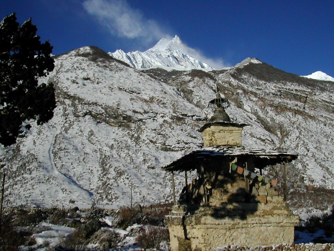
We set up camp in Lho, a lively, sprawling village adorned with many prayer flags, in the yard of a small lodge just above the new chorten that was built in 2009. Sunset and sunrise from the campsite are wonderful, and the small gompa just below our campsite worth a visit. From camp, we have breathtaking views of Manaslu and Manaslu north.
Day 14: Trek to Sama Gaon (Ro) 3525m:
Walking through the upper reaches of Lho, with the snowy peaks of Manaslu ahead of us in the distance, we pass the new gompa and then ascend through light forests next to a small river to reach the high, idyllic Tibetan settlement of Shayla, where the villagers are often out in the fields. Amazing mountain panoramas from here!
*** There is a great alternative route to Hong Sangbu Gompa en route to Shayla. The gompa is near Musithang Kharka, and has an entrance kane and a long mani wall.
We have a few hours of trekking through classic alpine scenery, crossing two small bridges over glacial streams. Our trail leads us past Tibet grazing settlements, the trail to Pung Gyan Gompa off to the left, several doksas, or seasonal settlements and eventually past checkered fields of barley and potato to Sama Gaon, or Ro, as the locals call it.
Sama Gaon sits in a bowl at the foot of the pastures leading to the high peaks, with mani walls, a small gompa and tightly packed rows of houses at the lower reaches of village, and the large gompa at the upper reaches. The people settled here from Tibet over 500 years ago, and the two gompas date from this time, both having unique architecture and built of wood. The Tibetan villages in this region of Manaslu have distinctive entrance gates (kanes), and they maintain an active trade with their co-religionists in Tibet over several high passes nearby. If the weather is good, you will see the village women weaving wool (baal) from Tibet into gowns - which are then traded back to Tibet. Taxes were actually paid to the Dzongka Dzong (fortress) at the border of Tibet, a few days walk from Sama Gaon, as late as the 1940's until it was taken over by the Gorkhas in the late 19th century. Later, after 1959, the region was home to Tibetan guerrillas, and thus closed to trekking until 1992.
Take the afternoon to hike up to the old gompa settlement above town, and to wander the streets of the fascinating Sama Gaon village.
Day 15: Sama Gaon
We have a rest day in Sama Gaon to explore the village and gompas; a little piece of old Tibet! This is also an extra day in case anyone is having trouble acclimatizing.
A great excursion is a hike to (or towards) Manaslu Base Camp, just north and off to the left of the trail leaving Sama Gaon, where we'll have stunning views of the lake, glacier and valley. This will take most of the day, so we'll pack a lunch for anyone wanting to go. Another option is a long day-hike up to Pung Gyan Gompa, at 3870 meters, a stunning walk up an often icy and slippery trail along the Numla Khola and the Pung Gyan glacier past Tibetan 'kharkas' or seasonal herding settlements, with unbeatable views of Manaslu near the gompa. The gompa was mostly destroyed by an avalanche in 1953, and recently rebuilt. The complex includes a cave gompa as well, which affords even better views of the valley.
Day 16: Trek to Samdo (3850m):
Another day of incredible mountain views, past craggy woods of Himalayan Birch, during the walk up to Samdo, an easy three hours away. En route we cross the river on a small bridge and river rocks, continue along the left side of the long Mani walls at Kermo Kharka, and soon afterwards spot the entrance chorten of Samdo high on a bluff. We descend back to the Bhuri Gandaki and cross a small bridge before another short climb to the 'kane' entrance of Samdo.
The villagers of Samdo came across the border from the village of Riu in Tibet after 1959 and built their new village here, at their old herding settlement. Like the people of Ro, Samdo inhabitants are Tibetan, and were ceded the land by the king of Jumla over 500 years ago. Since then they have established a trade with China and India, marketing among other things, the aphrodisiac root that grows in the region. We'll see if we can get an invitation into a local house for chang (Tibetan barley beer), salt-butter tea and perhaps a bit of carpets or textile shopping. Get out and take a walk around the village, where the inhabitants live an essentially Tibetan lifestyle, herding their yaks, sheep and goats, training their horses and planting barley.
We're high, and the wind can be chilling in the evenings, so tuck into the little tea-house next door to our campsite for a cup of salt-butter tea to warm you up!
Day 17: Samdo:
Another rest and acclimatization day in this wonderful spot below Manaslu, which towers above us. We recommend a hike up the valley directly in back of Samdo, with Samdo Ri behind it, heading towards one of their trading passes to Tibet, for amazing mountain panoramas including an in-your-face view of Manaslu itself. From left to right: Simrang Himal, Himal Chuli, Ngadi Himal, Manaslu, Manaslu North and Larkye Peak. To the right of the Larkye La which is just in front of us as we look northwest, we can see Cheo Himal and possibly Kang Guru behind the pass. En route up and down to these viewpoints we'll pass many lovely, slated herding settlements, called doksas, now empty. We might also see more Danphe as they crash through the underbrush, and probably will see Lammergeyer and Himalayan Griffin soaring high above us. The prayer flags strung up on a distant hill, sending messages out into the Himalaya; make a good stopping point before returning to lively Samdo.
A longer option for the day is a trip to the Gya La ('large pass') to the north of Samdo, a more frequently used trading route to Tibet where the border markers at the top says 'China, 1962.' We will probably share the trail with groups of Samdo residents, carrying timbers over the border to Tibet. True High Asia, and a long day!
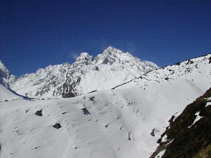
Day 18: Trek to Dharamsala High Camp (Larkya Phedi) 4460m:
We leave Samdo on the old trade route towards Tibet (Sherpas from the Khumbu region used to bring their yaks into Tibet and then across the Larkya La down into Nubri on their extensive trade-circuit in years past), cross a small bridge, and climb through the ruins of Larkya Bazaar across from Larkya Glacier which tumbles down from Manaslu North. The bazaar was one of the trade markets, a seasonal tented camp that flourished years ago. After three to four hours of climbing past more glaciers, through open plateaus of dwarf rhododendron and juniper bushes, with increasingly awe-inspiring panoramas, we come to the campsite at Dharamsala, the high camp for the Larkya La pass. We'll have lunch here while the staff sets up camp and gaze out at the views. You'll really feel the altitude and the cold here, so enjoy a more leisurely afternoon and keep warm. We're in blue sheep territory, so keep an eye out for herds of them grazing nearby on the barren hill-sides. We'll have an early dinner in preparation for our pass crossing tomorrow.
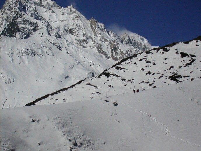
Day 19: Cross Larkya La (5140m) to Bimtang 3590m:
We pack up our bags and tents in the morning and head off on our eight to nine our trek! After a short climb above the campsite, we reach the ablation valley on the North side of the Larkya Glaciers where we have views of Cho Danda, Ganesh Himal l to the east and then of Larkya Peak (6250m). We continue across the moraines of the glacier and past frozen lakes, often through the snow, making a gradual ascent which becomes steeper only in the last section to the pass, which should take us about four hours to crest. If there is fresh snow, we may see snow leopard prints from the evening before; it's also blue sheep, pika, marmot and Tibetan snow-cock territory.
The views from the top of the pass are wonderful; a mountain panorama of Himlung Himal, Cheo Himal, Kang Guru, Gyagi Kung and the huge Annapurna II, equally stunning from both sides of our double pass. After hanging our Tibetan prayer flags and yelling 'Ki ki so so lha gyalo' (may the Gods be victorious), get ready for a steep, often slippery drop to a trail following the glacial moraine. Bring your trekking poles, and 'yak tracks'! We'll lunch below the pass on smooth rocks before continuing the descent, still three hours to go to our campsite. A boulder-strewn descent brings us, finally, to Bimtang, meaning 'Plain of Sand' where the Samdo people keep their animals. The three sisters of the 'Three Sisters Hotel' are on hand with chilled beer, and the evening clouds gather and turn pink behind the surrounding peaks. It's all worthwhile now.
Day 20: Trek to Tilje (2300m):
A chilly but beautiful morning, as the sun hits the peaks around us long before the campsite. After leaving the grazing fields of Bimtang, we cross a boulder-strewn river, which recently flooded, on a wooden bridge and head down, down through open forests of brilliantly blooming rhododendron, past the doksas below Bimtang, passing Samdo-pa returning from shopping with their loaded horses. We'll lunch at a small tea-house, and then continue along the rocky river-bed and sliding hill-sides to several small, green villages, a sign that we've reached lower altitudes. Eventually, after a somewhat long but very scenic day, we reach the large village of Tilje, and our campsite in the lower section. The inhabitants are a mix of Manangis (of Tibetan descent) and Chettris (Hindus), so have a unique architecture and culture, and eat mix foods - dal bhat, buckwheat dhiro, tsampa and Tibetan salt-tea. The gorge ahead marks the land of apple pie, cold beers and hot showers, otherwise known as the Annapurna Circuit.
Day 21: Trek to Chame:
Continuing to climb through forests of pine and oak, we pass through Danagyu before coming to a thundering waterfall, where we turn left and head up the high trail to Koto. After an hour of lovely, open forests, we reach a clearing at the top of the trail and a charming Tibetan teahouse where we will stop for a break. Pausing for breath, we can look back for views of Manaslu. An hour away is the wonderful Gurung village of Timang, where the villagers might be harvesting their crops of buckwheat or stuffing local sausages. Heading back down to the village of Koto Qupar, our base for the trek up to Nar Phu, we can look straight up at nearby Annapurna II - a stunning sight convincing us that we are deep in the Himalayan mountains! Many of the villagers are the from Nar Phu valley; this is the gateway to their region. Less than an hour brings us to Chame, the local administrative center of Manang, and a large village packed with small shops and tea-houses, an army post and a large school. We bed down here for the evening.
Day 22: Trek to Pisang
It's a beautiful walk from Chame to Pisang, through woods with a few small ascents and wonderful views of the peaks soaring above us. We only have a five hour day, so we'll have the afternoon in Pisang to explore the village with its Tibetan mani stones and gompa, perhaps taking a walk up to Upper Pisang for amazing views of Annapurna II and Annapurna III. We might stay in Upper Pisang depending on what we decide to do the next day.
Day 23: Trek to Manang
We have two options today, the upper and lower route. The lower route takes about four hours and follows the main valley on an easy trail and the alternate route via Ngawal - the High Route.
Today's trail is one of the most scenic along the Annapurna route; we start the morning with a steep ascent to Upper Pisang, and another longer and steeper one to Gyaru, an old village just off the main Annapurna trail, an atmospheric Manangi village. Another two or three hours brings us to Ngawal; it's not a long day, but a spectacular one, during which we really feel that we are heading up into the mountains. Ngawal is a wonderful, old village of cobbled streets, prayer wheels, decorative water-spouts and beautiful architecture, obviously a hub of religious activity in previous times. We check into a tea-housed and enjoy the afternoon.
After lunch at the New Yak Hotel bakery (one of Kim’s favorite’s) it’s just a 20-minute walk past a series of unique and colorful chortens to Manang, at 3500m, a village of 500 or so flat-roofed houses, the headquarters for the region, and an interesting village packed with trekkers, bakeries and lodges. Manang is dominated by high peaks - Annapurna III and Gangapurna tower over it, and a dramatic icefall sits just across the river. There is an old gompa on the edge of town, many local teahouses, and some atmospheric, winding streets in the village leading out toward the Thorung La. Finally, guest houses, showers, cold beers! There is a 3 o'clock lecture on altitude by the Himalayan Rescue Association for anyone interested.
Day 24: Trek to Tilicho Base Camp
It's a fantastic hike from Manang to the Base Camp of Tilicho Lake (there is actually a lodge here). We head through Manang village, cross to the east side of the Marsyangdi River and then head into the 'interior' of the Annapurna circuit past several small Manangi villages and a new-ish half-way lodge, then crossing some sliding sand chutes to Tilicho Base Camp, a hike of about six hours. Keep your eyes open for blue sheep as there are large herd in this region. Tilicho Lake is a further hour and a half walk away.
Days 25-27: Trek via Tilicho Lake & Tilicho Pass to Jomsom:
Exploratory! We've scheduled three days to cross the Tilicho Pass, the first to the High Camp on the Manang side, the second crossing the pass to the Mustang side and the third reaching Jomsom, the headquarters of Lower Mustang. Here we will stay at the Trekkers Inn for the night and meet the Mustang group tomorrow. Showers, cold beers and internet await...
Note: Manaslu group will depart on a flight to Pokhara and Kathmandu tomorrow.
Day 28: Trek to Kagbeni (2900m):
We are greeted by the sound of jingling horse bells as we head north to Kagbeni and the Mustangi people pass by with their pony caravans. After sorting out gear and loading our porters, we trek up the windy Kali Gandaki valley to Kagbeni. The wide trail along a sandy, saligram-filled riverbed provides views of the surrounding peaks of Dhaulagiri, Tukuche and Nilgiri, and to the south the entire Annapurna Massif. Kagbeni, spectacularly situated atop a cliff overlooking the confluence of the Kali Gandaki and the Jhong Khola rivers, is the last village in Lower Mustang and guards the entrance into Upper Mustang, visible across the Kali Gandaki riverbed. It is an oasis of green, patchwork fields in the midst of rocky, arid mountains, with Niligiri looming grandly behind it. This ancient, partially ruined citadel town provides us with a taste of scenes to come in upper Mustang, with its narrow alleyways and tunnels, irrigation canals, green fields of barley and its massive, newly-restored brick-red Sayka gompa, 800 years old. We'll also wander past the ancient, crumbing, 100-room King's Palace. At the police check post at the north end of the village where a sign reads 'Restricted area, tourists please do not go beyond this point', we will complete our paperwork to enter Upper Mustang tomorrow. We will have plenty of time to explore the village before joining the dinner.
Day 29: Trek to Tsaile (3060m):
After breakfast, we enter the restricted area of Upper Mustang with our staff and horse caravan in tow. We head high up a trail of scree to a ridge crest, which affords us wonderful views of the patchwork of Kagbeni and Niligiri down the valley. We continue trekking on the east bank of the Kali Gandaki, high up on the plateaus above the river-bed, all the time with magnificent views from all sides. The village of Tiri Gaon sits on the west bank of the river. We head north past the red, white and black chortens to the fortress-like Gurung village of Tangbe (3030m), a labyrinth of narrow alleys amongst white-washed houses, fields of buckwheat, barley, wheat and apple orchards, unique in Mustang with its moat-like drainage system. Tangbe is split into two sections, the ruins of its ancient dzong (fortress) in the upper section. There is a small, local tea-house here where we'll stop in for a break as it's taken us about three hours to reach the village. Nilgiri, which dominates the southern skyline at Kagbeni, continues to loom massively at the foot of the valley.
An hour and a half past Tangbe we reach Chhusang village (2950m) and a naturally-formed tunnel through which the Kali Gandaki flows. There is a salt mine two hours from Chhusang, and fortified Tetang village just up the same valley; the salt trade was of utmost importance to Mustang in years past, and much of the wealth of the villages came from this trade. Across the Kali Gandaki, high up in the dramatic, fluted rock face, are clusters of ancient caves, their origins lost in antiquity.
Day 30: Trek to Shyangboche (3765m):
After breakfast, we hit the trail, ascending steeply to a ridge above Tsaile. The scenery is awesome, the classic high altitude desert of the Tibetan high plateau. Our trail continues to ascend as we trek past the river valleys leading into the Kali Gandaki River. Soon we reach a spectacular, steep canyon-side trail leading towards the Dajori La. Across the canyon, there is a suspension bridge being built to access the remote village of Ghyakar. The pass, at 3600 meters, is marked by rock cairns and should take us 2 -3 hours to crest.
Samar is visible just below us; we descend gradually to a group of chortens on the ridge above the village, soon reaching Samar (3610m), with its lovely poplar grove, formerly a staging post for Khampa raids into Tibet. The Annapurnas, although still dominated by Nilgiri, are visible far to the south.
Passing through Samar, we go through the entrance and exit 'mane' chorten and descend steeply on a switch-back trail to the Samarkyung Khola (river) where we soon take the right fork, ascending once again to the chorten-topped Bhena La, at 3840 meters. We continue past the seasonal Bhena village along a lovely, high, wooded trail with wonderful, broad vistas across the canyons, climbing sharply up to the Beg La, really just a ridge, and past the two-house seasonal village of Yamda. We eventually reach the Yamda La, at 3985 meters, and are rewarded with a pass topped by a large cairn and a tangle of multi-colored Tibetan prayer flags, called 'lung ta' or wind horses. The views from the top are spectacular, so we stop for a break to enjoy them!
A steep switch-back leads to the small hamlet of Shyangboche (3765m), a remote herding outpost with three campsites and lodges, where we set up camp for the night.
Day 31: Trek to Dhakmar (3820m):
A short climb just after breakfast to the Shyangboche La, where the trail intersects a wide east-west valley and it's a quick descent to the picturesque village of Geling. There is an old gompa above the village, ancient meditation caves in the eroded cliffs visible above, a new school and traditional Mustangi houses surrounded by barley fields. From Geling, the trail climbs gently to the chorten at the lower end of Chhunggar, where we intersect the trail from the Shyangboche La, and then on to a large, colorful chorten at the opposite end of the village. Once through the hamlet of Zaite, we head up a new, dirt road to the Nyi La (4000m), about 2 1/2 hours past Geling. We descend on the new road, often cutting off on switch-backs, keep contouring around hillsides to the Ghemi La and then descend steeply down to the large village of Ghemi (3570m), where we stay on the way back.
Passing all the way through Ghemi, built along the steep edges of the cliff as many villages in Mustang are, we take a small, rocky trail down to a bridge crossing the Tangmar Chu (river). From here, the trail looks across the valley to ochre, blue and steel-grey cliffs, and leads us past tri-colored chortens and perhaps the longest and most spectacular Mani wall in Nepal, behind which is the hospital. Looming ahead of us is a cluster of gigantic, ancient chortens, backed by dramatic, sculpted cliff-faces, an awesome sight.
We continue along the western route, stopping occasionally for passing herds of sheep and goats, soon arriving at the small village of Dhakmar, which is dominated by a dramatic, red canyon wall with many ancient cave dwellings. Here we set up camp for the night, another good trekking day! Sunsets against the red cliffs are worth a look!
Day 32: Trek to Tsarang (3575m):
Another great day in front of us as we head slowly up valley and cross first ridge of the Mui La (4175m); the views down the Dhakmar Valley are breath-taking, as is the sight of our horse cresting the tunnel-like pass. We drop back down and the climb yet again through high meadows by a meandering, rocky stream to the true Mui La (4130m). Finally, Lo Ghekar, 'Pure Virtue of Joy', sitting majestically in the valley below us. Ghar Gompa is reputed to be one of the oldest gompas in Nepal, and is connected by legend to Samye Gompa in Tibet, as well as to the ubiquitous Guru Rimpoche. The name means 'house gompa' after the style of architecture, and it harbors many frescoes as well as wonderful carved and painted stones.
After lunch on the grassy gompa lawn, we head down the valley, through the long, scenic village of lower Marang (the upper village is built on the plateau above), cross a long suspension bridge over the Tsarang Khola and then trek another hour or so past fields, now apparently not irrigated, to the fortified village of Tsarang, perched on the edge of a dramatic canyon, where we camp for the night at a grassy campsite.
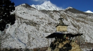
Tsarang is a large village built on top of the Tsarang Khola canyon, stone walls separating the houses and forming tunnel-like paths, with willow trees and a new irrigation ditch, many shops, its own hydro-electric plant and quite a few guest houses. It is dominated by the gigantic, five-story white Tsarang Dzong, a Tibetan-styled fortified palace built in 1378, and the large, ochre-hued Tsarang Gompa, of the Gelugpa school, with the greatest library in Lo. The dzong and palace have a wonderful, old prayer room with a gold-printed prayer book and a fascinating array of statues, thankas and large Buddha paintings that the resident lama will show you, and the withered 500 year old hand of the master architect of the palace! Elaborate sand mandalas are created at the gompa at festival time, and then ceremonially deposited into the river at the festival’s end. Take a walk through the maze of paths to the dzong and friendly gompa before dinner, and stop in at one of the many shops for a look. The local women will be herding their sheep through the narrow, walled paths at dusk.
Day 33: Trek to Lo Manthang (3820m);
Leaving Tsarang on a trail leading down and across the Tsarang Khola, we climb steeply up a rocky trail to a cairn on the opposite ridge and then follow the Thuling Khola on the new, dirt road towards Lo. The multi-hued canyons spread themselves impressively around us, and in the distance we see the huge Sungda Khola. Once past that landmark, we reach the tiny, green doksa of Sungdala, where we'll stop for tea and maybe lunch at the one small tea-house. Continuing along the same trail, the landscape becomes very Tibetan in character, the high desert plains of the Himalaya. We start to see snow peaks ahead of us as we near the Lo La pass, at 3960 meters. The pass leads through a partial tunnel of rock, and to the right of this are strung Tibetan prayer flags. Climb to the ridge to the right for wonderful views of Lo Manthang, aptly named the ‘Plain of Aspiration', below us.
The fabled walled city of Lo, with a single entrance through which only the King, Queen and Kempo (Abbot) are allowed to ride - all others must walk, to pay their respects to Chenrizig - is a mythical city. King Jigme Palbar Bista, called 'Lo Gyelbu' by the Mustangis, still resides at his four-storied palace inside the city walls; that is, when he’s not in Kathmandu. He is an avid horseman, and keeps his own stable of horses, some of the best in Mustang. These days, the king plays a somewhat ceremonial role although he is well loved and respected throughout Mustang. The present king is the 25th descendent of Ame Pal.
There are four major temples within the medieval walls of Lo, the 14th century, brick-red Jampa Lhakhang (the oldest gompa, built in 1387, with the striking 50 foot 'Jampa' (Future) Buddha, the largest clay statue in Nepal until a few years ago), 15th century Thubchen Gompa (Great Assembly hall, pillars 30 feet high, the second oldest gompa with fantastic murals in the Dukhang), Chhoede Gompa (where the Kempo lives, with a monastic school) and Choprang Gompa. There is also the Raja's Palace, home to the present King Raja Jigme and Queen 'Rani Sahib' (who is from an aristocratic Lhasa family) and an interesting maze of a village to explore. There are approximately 1100 Lobas and 180 houses within the walls of the city although many lower caste Lobas live outside the walls. Many of the Lobas still practice polyandry.
In the 1380’s, King Ame Pal established his reign in Lo, with the walled city of Lo Manthang as the capital and its inhabitants called Lobas. Within the walls of Lo Manthang are about 150 houses built among narrow streets, and some of the largest and finest Tibetan Buddhist gompas in Nepal. The city is quite prosperous due primarily to its past salt and wool trade along the Kali Gandaki with Tibet, and the Lobas themselves are still very Tibetan, living in Tibetan-style dwellings which we'll have a chance to visit. There are even yeti (known here as mehti) prints rumored to be found.
We'll get camp set up in a scenic, green, willow-lined campsite called 'Green Camping Site' and once we get settled in, we'll have plenty of time to marvel at the surrounding panoramic views of the Tibetan Plateau and the Himalaya.
Day 34: Lo Manthang – Visit the Chosar & Tingkar Valleys
Note: We recommend horses for anyone wanting to come along on this day-trip; others are free to stay and wander the intriguing streets of Lo. There is an amchi that runs a Tibetan herbal medicine clinic in town, two schools and even a coffee shop along with the increasing number of shops to visit.
Leaving Lo along a wide, canyon trail, past dry gullies and an ancient, ruined fortress, across a bridge and through a cultivated area, we finally view the cave village of Chosar, with the deep-red Nyphu Gompa built into the rock face. We'll need to cross two bridges to arrive at the gompa, at 3760 meters. Plenty of time for photographs before rounding the chorten-toped bend, where we get views of Gharphu Gompa on the east banks of the Mustang Khola. Past the gompa is an incredible cave-dwelling site called Jhong Cave, which you negotiate by ladders and through small tunnels, very interesting and reputed to be 2500 years old. In front of us, a range of spectacular snow-peaks marks the border with Tibet, and around us gurgling streams and green meadows line our trail. If we take the long loop, we can stop at Nyamdo Gompa, ride over a small pass and then head back down the western valley to Lo.
Day 35: Trek to Mid-Camp/Sam Dzong
Sadly, we must leave magical Lo, but new adventures await us on our route south. Back out the gates of Lo, and up to the Lo La pass where we have one last glimpse back down to this mythic, walled city. Back down the main trail for a few minutes until we see the sign marking the intersection to Dhi & Yara, and then we veer left (east) off the trail and head to Dhi along the eastern, winter route. We follow the trail along the western side of the Mustang Khola, contouring around tiers of high, arid slopes, a spectacular walk high up in the expansive, colorful canyons and gorges. Once over what we called the Dhi La (4090m), the really interesting trail begins; heading straight down a narrow, sandy trail, we reach the intersection to Tsarang, but continue straight down a steep, dramatic trail towards Dhi, eventually visible as a green swath far below us, with Yara and Ghara in the distance. Soon, we reach the windy village of Dhi. Take a quick walk through this little-touristed village for a taste of old Mustangi life.
Day 36: Trek to Chuchu Gompa
*** This is the exploratory section, where we spend five exciting days exploring the little visited eastern valleys of Mustang, in search of the last nomads living in the region and the cave-gompa that Peter Mattheissen features in his book, 'East of Lo Manthang'. The nomads live in the shadow of Dhaulagiri on the high plateaus, living as they have existed for centuries in their yak-hair tents, herding their pashm goats and sheep. Chuchu Gompa is a remote cave-gompa filled with exquisite and ancient Tibetan Buddhist murals, taken care of by a lone monk from Yara village. The route to Chuchu Gompa is rarely used by Westerners but is what we are sure to be Matheissen's un-named caves. This will be an exciting day.
Day 37: Trek to Nomad Camp
Another remote and exploratory day during which, at the end of the day, we should reach the nomads living their traditional Tibetan Buddhist nomadic lives. There are reputed to be only two nomadic families left in Mustang, our 'last nomads'. It will be interesting to contrast how these nomads live as compared to their neighbors in Tibet and Ladakh. We will look for a good camp near the nomads (if and when we find them).
Day 38: Trek to Chuchu Valley Camp
We retrace our steps back to the Chuchu valley, camping en route ...
Day 39: Trek to Yara 3610m
Veering off our nomadic route, we intersect the trail to Yara, Dhi and Luri Gompa. We camp for the night in the courtyard of a local guest-house in Yara, a bustling campsite full of Mustangi life.
Day 40: Yara (Daytrip to Luri Gompa)
Descending back to the Puyang Khola on a narrow, tunneling trail, we head further east, keeping below the village of Ghara; to the left are fantastic, sculpted canyons with the remains of a network of ancient caves, now eroded enough to be inaccessible. There is a newly discovered group of six cave dwellings nearby, the 15th century Tashi Kumbum, with incredible ancient murals and a large exquisitely painted chorten. It takes us approximately another one and a half hours to reach the fabled Luri Gompa of the Kagyupa sect and its complex of caves, some of which are accessible. There is a small gompa in the lower section, and the teacher, kids in tow, led us up to the upper prayer-room and the famous fifteenth century 'Kabum Stupa' painted with wonderful murals of the Kagyupa saints Tilopa, Naropa and Marpa.
The Luri caves are filled with wonderful, 'Newari-style' (Gary McCue) Buddhist frescos and large, intricately painted chortens. Historians estimate them to be from the 13th or 14th century, and linked to the Tashi Kumbum caves, one of a group of connected cave dwellings throughout this particular region. Unfortunately, or fortunately, most have been rendered inaccessible due to the intense erosion in Mustang, so will remain hidden throughout history.
On the way back, we take the high trail through the interesting village of Ghara, surrounded by terraced fields, before reaching Yara again.
Day 41: Trek to Ghemi (3570m):
Leaving Yara, we trek past the incredible fluted cliffs embedded with caves and the saligram-filled river valley, narrowing as we get closer to the Kali Gandaki, to the village of Dhi, just past Surkhang village which we pass on the right of the valley. It's a fantastic day of trekking through the spectacular Kali Gandaki gorge; leaving Dhi through the southern end of the village, we trek along the sandy, rocky riverbed, the sides of the canyons soaring above us, the rocks forming strange sculptures. We follow a small, locally-used riverside trail for a few hours, and start to climb when we reach a chorten and sign pointing us towards Tsarang and Ghemi. It's a steep switchback up to an old, grey chorten perched on a ridge, from where we have expansive views up and down the Kali Gandaki valley, and after a rest we keep climbing until we reach a new trail being built high above us. Heading south, we walk along the large, sandy trail for a while, with Tsarang visible to our north. We crest the Tsarang La (3870m) and then head back down towards Ghemi, passing by the huge chortens and Mani walls en route. Again over the small bridge over the Ghemi Khola, and then up the small, steep trail to Ghemi, where we pass through the village to our beautiful, green campsite in the upper reaches of Ghemi.
Ghemi is a sprawling village of white-washed houses and terraced fields, with a gompa in the process of restoration and a red nunnery at the far end of the village, fields of billowing buckwheat glowing in the evening sun. Take a walk through the village in the late afternoon when it's most lively!
Day 42: Trek to Samar (3600m):
We head back south, retracing our path over the Ghemi La and Nyi La passes, and then continue on via a different route through Zaite, Chhunggar and Tamagaon to reach the Syangboche La at 4000 meters, and then Syangboche village two hundred meters below.
Once below Syangboche, we veer off to the left and descend into the valley, past seasonal doksas and shepherds herding their flocks of sheep and goats, on the eastern route to Samar via the important Chungsi Caves. En route, we see many nests of Himalayan Griffins high up in the cliff-faces, noticeable from their white below them (vulture droppings), and will see these majestic birds with their three meter wing-spans circling high above us. It should take us about an hour to reach the Chungsi Caves, one of the ubiquitous Guru Rimpoche's meditation caves. Up a series of rock steps to the entrance, and inside are fantastic 'rangjung' or self-created Tibetan Buddhist sculptures, chortens and others Buddhist relics.
We've now got a steep but spectacular walk in front of us as we head towards Samar, which means 'red earth' in Mustangi. We climb high up into an incredible, vast canyon, with wonderful, expansive views the entire time, and reach the Chungsi La (3810m) in a few hours. Then down, again steeply, to the Jhuwa and Samarkhung Kholas, and back up the switch-backing trail to the entrance chorten of Samar. A good day's trekking! Camp is in a lovely, shaded spot at the far end of the village called Hotel Annapurna, owned by Namgyal Gurung; it has a welcoming tea-house in the lower section where we'll stop in for a cup of salt-butter tea. Relax, have a wash in the cold stream next at the campsite, and enjoy the afternoon and sunset over the Himalayan peaks in this charming village, which translates as 'red earth'.
Day 43: Trek to Tetang (3000m):
It's an easy hike up the Dajori La, and a long, wonderful descent along our cliff-side canyon trail back to Tsaile and then along the riverbed to Chhomnang. We'll now head to Tetang, an incredible, fortified village on the way to the salt mine, for a bit of exploration and photography. Tetang is a wonderfully situated village, with massive houses peppered with small holes, for what purpose we still haven't discovered. Perhaps as holds for scaffolding? The ruins of an ancient, crumbling dzong stand majestically on a crest at the northern end of the village. Earlier, we witnessed a 'village women's' council' over the use and shortage of water, a heated discussion. We'll camp just outside of camp, at a windy campsite next to a local dwelling, and have the afternoon free to explore fortified Tetang.
Day 44: Trek to Muktinath
Taking the remote route back to Muktinath, we trek through Tetang village and climb the 4075 meter Gyu La, a trek of about two hours or more, for views down to Lower Mustang, and then descend a long, contouring trail heading to Muktinath where we camp for the night. We may choose to not stay right in Muktinath itself and to stay in a quieter village instead.
Muktinath is an important pilgrimage site for Buddhists and Hindus situated in a tranquil grove of trees, and contains a wall of 108 waterspouts in the shape of cows heads spouting sacred water, the Jwala Mai temple with a perpetual spouting flame and the pagoda-styled Vishnu Mandir, all of which make up the auspicious combination of earth, fire and water. We stay just five minutes down the trail from Muktinath at Ranipauwa.
Day 45: Trek to Jomsom
After breakfast, we just have a gentle walk back down the Kali Gandaki to Jomsom. Along the way, beautiful textiles are woven by hand looms in the traditional style, and are readily available for sale by eager Mustangi women. Yak tails to adorn your horses or dust your house also for sale. We arrive in Jomsom along a long, cobbled trail in time for lunch, with the afternoon free to wander, wash and shop. We'll celebrate our trek through 'forbidden' Mustang with a few cold beers at the Trekker's Inn in the evening!
Day 46: Fly to Pokhara & Kathmandu\
Sadly, it's time to leave the magical Kingdom of Mustang and head back to Kathmandu. We board an early morning mountain flight from Jomsom, switching planes in Pokhara for a Kathmandu flight, and hopefully arrive Kathmandu in time for lunch. Rest of the day is at leisure.
Day 47: Kathmandu- free day
Day 48: Sightseeing tour of Bhaktapur and Patan followed by farewell dinner in the evening.
Day 49: Final departure
Extra Days in Kathmandu
If you wish to stay longer, we can offer plenty of suggestions: mountain biking or rafting, an Everest sightseeing flight, a night at the Fort Hotel in Nagarkot for a bit of luxury and expansive sunrise/sunset mountain panoramas, visits to interesting temple villages such as Changu Narayan, a few days at Barahi Hotel in Pokhara or a relaxing excursion to Chitwan National Park. Let us know if you will have some extra time to indulge yourself in these activities and we would be happy to craft the itinerary for you.
- All ground transfer by private vehicles as per our itinerary
- Fine hotel –Thamel Eco Resort in Kathmandu (twin sharing including b/f and taxes)
- Welcome dinner with live Nepalese cultural program hosted by Makalu Adventure
- Guided sightseeing around Kathmandu world heritage sites including all entrance fees
- All domestic airfares (Jomsom-Pokhara-Kathmandu)
- Organized camping trek arrangements including all high quality German Salewa / UK Super Quasar camping equipment such as two men tent, kitchen tent, dining tent, toilet tent, tables, chairs, mattresses, hot water bags, pillows, inner sheets etc.
- Everyday three times hot meals while on trekking prepared by our professional kitchen crew.
- National park, conservation area permit and fees
- Guide, porters, their daily wages, insurances with all necessary lodging / fooding arrangements.
- Administration service during rescue and evacuation (if required)
- Down jacket, sleeping bags, Trekking kit bag/duffel bag, trekking map and trekking Poles
- A comprehensive medical kit
- All government and local taxes
- Nepal visa fee.
- Airport taxes.
- International airfare to and from Kathmandu.
- Excess baggage charges.
- Lunch and evening meals in Kathmandu.
- Extra night accommodation.
- Travel and rescue insurance.
- Personal expenses (phone calls, laundry, bar bills, battery recharge, extra porters, bottle or boiled water, showers etc).
- Rescue and evacuation if required.
- Tips and gratitude