- Home |
- Why With Us |
- About Us |
- Booking |
- Contact Us |
- Site Map


Makalu Barun National Park
 High in the heart of the eastern Himalayan, seven valleys radiate from Mt. Makalu, the world's fifth highest peak. These valleys, particularly the Barun valley, treasure some of the last remaining pristine forest and alpine meadows of Nepal. From the bottom of the Arun valley, at just 435 m above sea level, the Himalayas rise to the snow-capped tip of Makalu 8463 m within a 40 km distance. Within this wide range of altitudes and climates, the Makalu-Barun area contains some of the richest and most diverse pockets of plants and animals in Nepal, elsewhere lost to spreading human habitation.
Nestled in the lower reaches of these valleys are communities of Rai, Sherpa, and Shingsawa (Bhotia) farmers. Though economically poor and isolated, they retain a rich cultural heritage. They hold the key to the preservation of the unique biological and cultural treasures of the Makalu-Barun area.
The Makalu-Barun National Park and Conservation Area was established in 1992 as Nepal's eighth national park and the first to include and adjacent inhabited conservation area as a buffer. A new park management approach encourages local people to become actively involved in protecting the forests and natural resources upon which their lives depend, and in conserving their own rich cultural heritage. Traditional resource management systems, such as community controlled grazing and forest guardianship, are being strengthened and low level technologies introduced where appropriate. Working in collaboration with an American NGO, Woodlands Mountain Institute, the Government of Nepal is striving to improve local living standards through infrastructure, educational and income-generating activities.
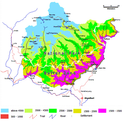
Covering 2330 sq. km Makalu-Barun is a vital component of the greater Mount Everest ecosystem which includes Nepal's 1,148 sq. km Sagarmatha (Mount Everest) National Park to the west and the 35000 sq. km Comolangma Nature Preserve in the Tibet Autonomous Region of China to the north.
History
The idea of preserving the unique biological and cultural features of the Makalu Barun area was already conceived in the 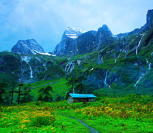 mid-1980s. The management plans accomplished in 1990 also addressed the issue of protecting the upper watershed of the Arun River. In 1991 Makalu Barun National Park was gazetted. When in 1999 the bufferzone was declared, the park was the first to include an adjacent inhabited conservation area. About 35,000 people reside in 12 Village Development Committees, who are primarily subsistence farmers of Sherpa, Rai, Gurung, Tamang, Magar, Newar, Brahmin and Chhetri ethnic groups.
The inaccessible valleys of the Barun River, glacier-fed tributary to the Arun River, and of its tributary Saldima, treasure some of the last remaining pristine forests and alpine meadows. They have been designated as a Strict Nature Reserve, the first in Nepal, in order to protect natural ecosystems and processes in an undisturbed state for scientific study, environmental monitoring, education and the maintenance of genetic resources.
Features
From tropical forests along the Arun River to icy mountain summits, Nepal's Makalu-Barun National Park and Buffer zone, covering 1500 + 830 sq, km. is the only protected area on earth with an elevation gain of 8,000m. The skyline is panorama of rugged Himalayan peaks, including Mt. Makalu (8,463m) fifth highest mountain in the world and fourth highest in Nepal. Mt. Chamlang (7,319m), Mt. Baruntse (7,129m). Meera Peak (6,654m) and Nepal known as peak hill.
Climate
Makalu-Barun area falls in the eastern Himalayan climatic regime where monsoon starts early (June) and stays longer than in west Nepal (until late September). The climate is generally described as monsoon type, where more than 70% of the precipitation occurs between June and September. Pre monsoon rain is common during the month of April and May, an important factor in biomes production. No reliable records of climatic data represent the entire area- Great variations in temperature and precipitation can be expected due to extreme difference in altitude, slope and aspect within the area.
Vegetation:
The Makalu Barun National Park exhibits a high diversity of forest types that are characteristic for the Eastern Himalayas, ranging from near-tropical dipterocarp monsoon forest on 400 meters (1,300 ft) altitude to subalpine conifer stands on 4,000 meters (13,000 ft) altitude. Forest aspects vary depending on seasonal moisture availability, temperature and snow cover at different elevations and slopes. Forests below 2,000 meters (6,600 ft) are strongly affected by subsistence agriculture, so that only some ecologically significant stands remain there. Above 2,000 meters (6,600 ft) forests are usually extensive since the cool, humid climate suppresses agricultural activity.
Forests span in the Makalu Barun National Park has been categorized into five bioclimatic zones:
- Tropical – below 1,000 meters (3,300 ft) with stands of Sal;
- Subtropical - Himalayan subtropical broadleaf forests from 1,000 to 2,000 meters (3,300 to 6,600 ft) with stands of Schima and Castanopsis;
- Lower and upper temperate - Eastern Himalayan broadleaf forests from 2,000 to 3,000 metres (6,600 to 9,800 ft) with predominantly broadleaf evergreen species of Oak and Laurel families and broadleaf deciduous stands of Maple and Magnolia;
- Subalpine - Eastern Himalayan subalpine conifer forests from 3,000 to 4,000 metres (9,800 to 13,000 ft) with stands of Himalayan Birch and East Himalayan Fir; along a transect from outer, southern slopes to the inner valleys these stands are dominated by conifers such as Juniper and Fir.
- On alpine pastures above 4,000 meters (13,000 ft) - Eastern Himalayan alpine shrub and meadows - the religiously important dwarf rhododendron and juniper, aromatic herbs and delicate wildflowers prosper.
- Until now botanists recorded 3,128 species of flowering plants, including 25 of Nepal's 30 varieties of rhododendron, 48 primroses, 47 orchids, 19 bamboos, 15 oaks, 86 fodder trees and 67 economically valuable aromatic and medicinal plants.
Fauna
The protected area is habitat for a wide diversity of faunal species. There are 315 species of butterflies, 43 species of reptile and 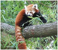 16 species of amphibians. 78 species of fish inhabit the many ponds, lakes and rivers. Ornithologists have recorded 440 bird species, ranging from eagles and other raptors to white-necked storks and brilliantly colored sunbirds. The 16 rare or protected bird species include the rose-ringed parakeet, Blyth’s kingfisher, deep-blue kingfisher, blue-naped pitta, pale blue flycatcher, Sultan tit, silver-eared mesia and the white-naped yuhina.
The 88 species of mammals include snow leopard, leopard, clouded leopard, jungle cat, leopard cat, jackal, Himalayan Wolf, red fox, red panda, black bear, Hanuman langur, Assam macaque, Himalayan tahr, Himalayan goral, muntjak, musk deer, barking deer, Himalayan serow, wild boar, flying squirrel, otters, spotted linsang, weasel and marmot.
Park facilities
The Makalu-Barun National park and Buffer zone headquarter is located at Murmidanda. Seduwa. A kerosene depot at Makalu Tourism Association as well as private lodgers in Tashingaou sales kerosene to all trekking groups including the porters. Makalu Tourism Association rent kerosene stoves and blankets for porters. The trekking group has to provide the facilities to the porters. There are four shelters built for the use of porters while they are inside the park. Neither the staff nor the porters should make fire inside the shelter as it is only for sleeping purpose.
Strict Nature Reserve:
The inaccessible lower Barun valley, a glacier-fed tributary to the Arun river, and its tributary the Saldima, flow through the most pristine area in the Park and thus have been designated as a Strict Nature Reserve, the first in Nepal. Here natural ecosystems and processes will be protected in an undisturbed state for scientific study, environmental monitoring, education, and the maintenance of genetic resources.
Trail safety
Most trails are quite rocky, and become slippery after rain or overnight freezes. Until April or May, winter snows generally stay on the passes and on high altitude trails approaching shershong. One particular hazardous area is the trail between Mumbuk and Yangle Kharka, an area of unstable and dangerous Rock fall. Trekkers in this area should move quickly and watch for falling rocks. Mountain sickness can also be a serious risk if elevation gains are rapid without proper acclimatization.
Camping regulations
Campsites have been designated along the trek route. The purpose of this designation of campsite is to regulate the impact on vegetation, aesthetic, landscapes damage and waste management etc. Seven campsites have been designated in (Khongma 3500 m, Dobato 3500m, Yangle 3570m, Neghe 3700m, Langmale 4100m, Shershong 4600m) for tourist.
How to get there:
There are different alternatives to visiting the Makalu Barun National Park, all involving a good deal of trekking up to the park. You could fly from Kathmandu to Lukla, Phaplu, Lamidanda, Bhojpur and Tumlingtar airstrips, and then trek to reach the park. Alternatively, you could also fly to Biratnagar and drive to Dharan and then to Hile. From Hile you can trek to the Park Area.
Entry fees into Makalu Barun National Park and Conservation Area:
National Park entry fees per person per entry:
- For Nepali Nationals Free
- For SAARC Nationals Rs 100
- For Foreign Nationals Rs 1000
- Children under 10 years Free

National Parks

Wildlife Reserve