- Home |
- Why With Us |
- About Us |
- Booking |
- Contact Us |
- Site Map


Annapurna Conservation Area
Considered among the top ten trekking circuits in the world the Annapurna Conservation Area covers 7,629 sq km 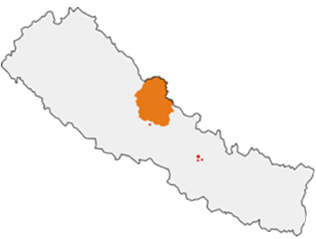 and is spread around Kaski, Mustang, Manang and Lamjung districts in north central Nepal. This is one of Nepal's most diverse protected areas starting with an altitude of 790 meters and reaching as high as 8,091 meters to the summit of Mt. Annapurna. Due to its popularity there are numerous tea houses and lodges all along the trails. The upper regions of the Annapurna Conservation Area fall in the Trans Himalayan regions of Mustang and Manang both of which are culturally closer to Tibet. Lake Tilicho at an altitude of 4,919 meters in Manang district is one of the destinations for many trekkers while the Thorang- La pass between Mustang and Manang at 3500 m has gained notoriety. Muktinath in lower Mustang is a major pilgrimage for Buddhists and Hindus alike.
Upper Mustang region has recently gained a surge of visitors after the discovery of more than 2000 year Buddhist old murals in cave dwellings here. The walled city of Lo Manthang the capital of upper Mustang is also one of the most popular destinations.
Trekkers to the region generally start off from Besisahar in Lamjung or Berithanti near Pokhara. Both towns are easily reachable by road from Pokhara or Kathmandu. The best season to visit the area is from March to May or from September to November. There are plenty of lodges and tea houses along the trail.
Brief History
- In 1986 ACAP was implemented by King Mahendra Trust for Nature Conservation in Ghandruk as a pilot project covering just one Village Development Committee (VDC) with area of 200 km2
- In 1990, it’s work area had expanded to 16 VDCs with an area of 1500 km2
- In 1992 the area was officially gazetted covering 55 VDCs encompassing the present areas
Features:
There are several features that make the Annapurna region a unique place in the world. It contains world’s deepest river gorge - Kali Gandaki Gorge, which is 3 miles long and 1.5 miles wide, a valley with fossils from the Tethys Sea dating 60 million years ago. The region contains world’s largest rhododendron forest in Ghorepani. Tilicho lake, located in Manang – north of Annapurna massif, is the world’s highest altitude fresh water lake.
Annapurna, while not as well-known to the outside world as Mt. Everest or K2, is still a very important peak to high-altitude alpine climbing. The peak rises 26, 538 ft., making it the 10th highest mountain in the world. Along with the climbing, Annapurna also happens to be the focal point for a 7,629 sq. km. conservation and protection initiative known as the Annapurna Conservation Area Project.
The biological diversity of the Annapurna region is equally rivaled by cultural diversity. Gurung and Magar are the dominant groups in the south, whereas Thakali, Manange and Loba are dominant in the north. Each of these groups speaks their own dialect, and have unique cultures and traditions. Besides, there are also Brahmin, Chhetri and other occupational castes although in comparatively smaller numbers. Hindu, Buddhist and pre-Buddhist religions along with a mixture of all these are prevalent across the region. The local people reside in the 5 districts of the 57 Village Development Committees (VDCs) of the Annapurna Conservation Area (ACA).
The natural and cultural features of ACA have made it the most popular trekking destination in the country, drawing more than 60 percent of the country’s total trekkers
Some features at a glance:
- Some of the world’s highest peaks (Annapuran I: 8,091m, Machhapuchhere: 6,993)
- World’s deepest gorge: Kali Gandaki and one of the world's highest altitude lake Tilicho
- Most popular trekking destination (76407 in 2000)
- Two distinct climatic regions (3000mm annual rainfall in south (cis Himalayas) and 500mm annual rainfall in north (trans Himalayas) within a span of 120 km and altitude of 1000-8000m.
- 22 different forest types
- A total of 1226 species of plants (1140 species in the cis Himalayas) including 38 Orchid species and 9 Rhododendron species
- 101 species of mammals including snow leopard, Musk deer, Tibetan Argali, Tibetan wolf, Tibetan fox. 474 species of birds including 38 breeding species of birds at risk in Nepal, all six Himalayan pheasants found in Nepal. 39 species of reptiles and 22 species of amphibians.
- Nepal’s largest protected area and first conservation area with the entire habitat gradient from sub tropical Sal forest to perennial snow.
- More than 100,000 inhabitants and more than 10 ethnic groups (Tibeto Burbese: Gurung, Thakali, Bhotia, Ethnic Tibetan and Magar and Indo Aryan: Brahmin, Kshetri, Kami, Damai and Sarki)
Vegetation and Wildlife:
The Annapurna Conservation Area offers innumerable sights of waterfalls, mountains, natural flowers and rural settlements.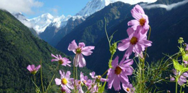 If you trek from the west you will be travelling along the Kali Gandaki River. Apart from natural sights, the area is rich with flora and fauna. There are above 1200 plants with around 40 orchids and 9 species of rhododendron - the national flower. There are around 100 mammals including the rare snow leopard and blue sheep in the upper sub-alpine area, 478 species of birds such as the protected multi-coloured Impheyan, koklas and blood pheasants. 39 reptiles and 22 amphibians and many types of butterflies in the area.
The Annapurna Conservation Area Project helps to protect an area that offers some of the finest trekking trails in the Himalayan region and the world. These trails have become a world destination for many venturing into the Himalayan region and offer a nice glimpse at the natural wildlife and ecology of Nepal. This area is the largest protected area in all of Nepal and has been looked upon as an area of prestige and pride.
Tourist Attraction:
- One of the most fascinating Trekking regions of Nepal with views of Himalayas higher than 8000 meters in elevation such as Annapurna ranges Mt. Nilgiri, and Mt. Dhaulagiri
- Scenic and culturally splendid places like Ghandruk, Poon Hill, Tatopani, Kalapani, Kagbeni, Muktinath-Jomsom, Upper/Lower Mustang, Thorung La Pass (5410m)Muktinath temple, the Kali Gandaki Gore, Tilicho lake and the world’s largest rhododendron forest at Ghorepani provide something for every visitors to this region no matter what one’s taste is like.
The Annapurna Trek
The Annapurna Conservation Area is a well known trekking region. There are three major trekking routes in the Annapurna region: the Jomsom Trek to Jomsom and Muktinath, the Annapurna Sanctuary route to Annapurna base camp; and the Annapurna Circuit, which circles the Annapurna Himal itself and includes the Jomsom route. The town of Pokhara usually serves as a starting point for these treks, and is also a good starting place for other short treks of one to four days, such as routes to Ghorepani or Ghandruk.
The Mustang district, a former kingdom bordering Tibet, is also geographically a part of the Annapurna region, but treks to upper Mustang are subject to special restrictions.
About two-thirds of all trekkers in Nepal visit the Annapurna region. The area is easily accessible, guesthouses in the hills are plentiful, and treks here offer incredibly diverse scenery, with both high mountains and lowland villages. Also, because the entire area is inhabited, trekking in the region offers unique cultural exposure and experience.
Land use pattern in Annapurna Conservation Area (ACA)
| Land Uses | Area km2 | Percentage |
| Barren land | 3,729.07 | 48.88 |
| Grazing land | 2,306.11 | 30.23 |
| Shrub land | 213.57 | 2.80 |
| Conifer forest | 214.93 | 2.82 |
| Hardwood forest | 679.18 | 8.90 |
| Mixed forest | 205.08 | 2.69 |
| Agricultural land | 243.90 | 3.20 |
| Orchard | 0.93 | 0.01 |
| Waterbodies | 36.23 | 0.47 |
| Total | 7,629.00 | 100.00 |
Administrative Divisions of ACA Project (ACAP)
The Annapurna conservation Area has been divided into 7 Unit Conservation Offices (UCOs) for better and efficient administration and program implementation.
| UCOs | Area(km2) | Population | VDCs |
Ethnic group | Focused program |
| Lomanthang | 2567.55 | 5,700 | 7 (all from mustang) | Loba | Biodiversity and cultural heritage conservation |
| Jomsom | 994.50 | 8,600 | 9 (all from Mustang) | Thakali | Tourism management |
| Manang | 1914.72 | 5,400 | 12 (all from Manang) | Manange Gurung | Tourism Management |
| Ghandruk | 807.75 | 21,000 | 5 (3 from Kaski,2 Myagdi) | Gurung,Magar,Kshetri, Bahun | Tourism Management |
| Lwang | 503.39 | 20,000 | 7 ( all from Kaski) | Gurung,Bahun,kshetri | Agro forestry |
| Sikless | 458.68 | 22,000 | 7 (all from Kaski) | Gurung,Bahun,kshetri | Integrated agriculture |
| Bhujung | 382.42 | 20,000 | 8 (all from lamjung) | Gurung,Bahun,kshetri | Poverty alleviation |
The Annapurna massif
The Annapurna massif contains six major peaks over 7,200 m:
| Annapurna I | 8,091 m (26,545 ft) Ranked 10th; Prominence=2,984 m | 28.595°N 83.819°E |
| Annapurna II | 7,937 m (26,040 ft) Ranked 16th; Prominence=2,437 m | 28.539°N 84.137°E |
| Annapurna III | 7,555 m (24,786 ft) Ranked 42nd; Prominence=703 m | 28.585°N 84.000°E |
| Annapurna IV | 7,525 m (24,688 ft) | 28.539°N 84.087°E |
| Gangapurna | 7,455 m (24,457 ft) Ranked 59th; Prominence=563 m | 28.606°N 83.965°E |
| Annapurna South | 7,219 m (23,684 ft) Ranked 101st; Prominence=775 m | 28.518°N 83.806°E |
Local Institutions
ACAP has been mobilizing the local people of the ACA in its conservation and development initiatives since the project inception in 1986. As a result there is a well developed network of local institutions in place that have formed on a VDC basis, where Conservation Area Management Committee (CAMC) is the primary institution. Under the umbrella of the CAMC, other sub committees are formed as per the need.
How to get there
Annapurna area conservation is located near Pokhara, towns easily accessible from Kathmandu by air and road .Bus or taxi services are available from Pokhara to Jomsom which is located in the northern part of Annapurna Conservation Area. Alternative route is to reach to Phedi by bus or taxi and walk 1.5 days to reach to Ghandruk via Dhampus -Landruk. Annapurna sanctuary and base camp is located at 6-7 days trek from Ghandruk.
Important Points:
- There are many small lodges/teahouses along the way which will provide food, drinks and accommodation.
- Government regulations prohibit lighting campfires in the conservation area. You need to carry kerosene and sufficient warm clothing.
- Visitors should carry out what they carry in. Place rubbish in the designated places.
- The flora and fauna in the area are fully protected. They should not be disturbed.
- Do not wear revealing clothing.
- Respect privacy. Ask before photographing people or religious sites.
Entry fees into the Annapurna Conservation Area:
Conservation Area fees per person per entry.
- For Nepali Nationals Free
- For SAARC Nationals Rs 200
- For Foreign Nationals Rs 2000
- Children under 10 years Free

National Parks

Wildlife Reserve