- Home |
- Why With Us |
- About Us |
- Booking |
- Contact Us |
- Site Map
- Home
-
Nepal
-
Trekking
- Arun Valley with Gokyo Lakes
- Everest Base Camp Trek
- Everest- A Living Culture Exploration
- Everest Explore
- Everest Base Camp (via Thame) Trek
- Everest Base Camp with Kala Patthar
- Everest Comfort Trek
- Everest High Passes with Ama Dablam Base Camp
- Everest Mani Rimdu Festival Trek
- Everest Nagpa La Trek
- Everest with three high passes
- Gokyo Ri, Chola Pass & Chukung Ri with Kala Patthar
- Gokyo with Everest Base Camp
- Jomsom - Muktinath
- Jomsom - Muktinath
- Khayar Lake Trek
- Manaslu and Tsum Valley with Larkya La
- Upper Mustang Trek
- Manaslu High Circuit
- Manaslu, Tilicho Pass & Upper Mustang
- Annapurna Base Camp Trek
- The Annapurna Circuit Trek
- Annapurna Panorama
- Nar and Phu Valley Trekking
- Nepal Rhododendron Trek
- Royal Trek
- Saribung Trek and Expedition
- Annapurna Sanctuary Trek
- The Annapurna Sunrise Trek
- Expedition
-
Rafting
-
Peak Climbing
-
Tours
- Kathmandu-Chitwan-Jungle Tour with visit to Pokhara
- Dawn to Dusk Tour
- Historical, Natural & Cultural Tour with Camping
- Kathmandu Valley Temple Tour
- Temple - Panorama - Jungle Tour
- Taste of Nepal
- Central Nepal Tour
- Explore Nepal Tour & Trek
- Nepal Cross-country Tour
- Best of Nepal Tour & Treks
- Kathmandu valley rim Tour & Treks
- Nepal Culture Tour
- Introduction to Nepal Tour & Treks
- Nepal at a glance Tour & Treks
- Wonders of Nepal Tour & Treks
- Glimpses of Nepal Tour & Treks
- Through the Silhouette Tour & Treks
- Tent and Temple Tour
- Kathmandu-Chitwan-Pokhara Tour
- Historical, Cultural City and Jungle Tour
- Nepal Wildlife Tour
- Nepal Panorama Historical Tour
- Nepal Adventure Tour
- Nepal Pilgrimage Tour
- Ghalegaun-Ghanapokhara Homestay Tour
- Jungle Safari
- Adventure Sports
-
Trekking
- Tibet
-
Bhutan
-
India
- Yoga Tour
- About Us
-
The Great Himalayan Trail
-
Short Tours/Treks


Sagarmatha National Park
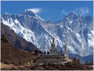 The Sagarmatha National Park includes the highest point of the Earth's surface, Mount Everest (Sagarmatha). The park is also of major religious and cultural significance in Nepal as it abounds in holy places such as the Thyangboche and also is the homeland of the Sherpas whose way of life is unique, compared with other high-altitude dwellers.
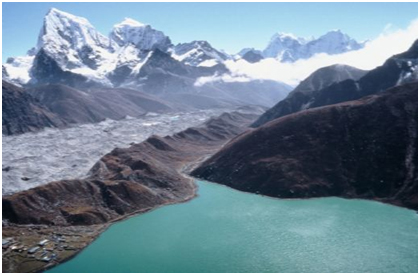
The park encompasses the upper catchments of the Dudh Kosi River system, which is fan-shaped and forms a distinct geographical unit enclosed on all sides by high mountain ranges. The northern boundary is defined by the main divide of the Great Himalayan Range, which follows the international border with the Tibetan Autonomous Region of China. In the south, the boundary extends almost as far as Monjo.
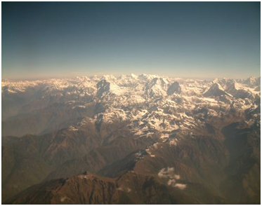
This is a dramatic area of high, geologically young mountains and glaciers. The deeply-incised valleys cut through sedimentary rocks and underlying granites to drain southwards into the Dudh Kosi and its tributaries, which form part of the Ganges River system. The upper catchments of these rivers are fed by glaciers at the head of four main valleys, Chhukhung, Khumbu, Gokyo and Nangpa La. Lakes occur in the upper reaches, notably in the Gokyo Valley, where a number are impounded by the lateral moraine of the Ngozumpa Glacier (at 20 km the longest glacier in the park). There are seven peaks over 7,000 m. The mountains have a granite core flanked by metamorphosed sediments and owe their dominating height to two consecutive phases of upthrust. The main uplift occurred during human history, some 500,000-800,000 years ago. Evidence indicates that the uplift is still continuing at a slower rate, but natural erosion processes counteract this to an unknown degree.
 In the region there are six altitudinal vegetation classed, from oak forests at the lowest elevations to lichens and mosses at the highest elevations. The Himalayan zone provides the barrier between the Palaearctic realm and the Indomalayan realm.
Most of the park (69%) comprises barren land above 5,000 m, 28% is grazing land and about 3% is forested. Six of the 11 vegetation zones in the Nepal Himalaya are represented in the park: lower subalpine; upper subalpine; lower alpine; upper alpine; and subnival zone. Oak used to be the dominant species in the upper montane zone but former stands of this species.
In common with the rest of the Nepal Himalaya, the park has a comparatively low number of mammalian species, apparently due to the geologically recent origin of the Himalaya and other evolutionary factors. The low density of mammal populations is almost certainly the result of human activities. Larger mammals include common langur, jackal, a small number of wolf, Himalayan black bear, red panda, yellow-throated marten, Himalayan weasel, masked palm civet, snow leopard, Himalayan musk deer, Indian muntjac, serow, Himalayan tahr and goral. Sambar has also been recorded. Smaller mammals include short-tailed mol, Tibetan water shrew, Himalayan water shrew; marmot, woolly hare, rat and house mouse.
Inskipp lists 152 species of bird, 36 of which are breeding species for which Nepal may hold internationally significant populations. The park is important for a number of species breeding at high altitudes. The park's small lakes, especially those at Gokyo, are used as staging points for migrants. A total of six amphibians and seven reptiles occur or probably occur in the park.
 There are approximately 2,500 Sherpa people living within the park. The people are primarily Tibetan Buddhists. Their activities are primarily agricultural or trade based. Their properties have been excluded from the park by legal definition. There is and will continue to be an influence on the people by the park and vice versa. The Sherpas are of great cultural interest, having originated from Salmo Gang in the eastern Tibetan province of Kham, some 2,000 km from their present homeland. They probably left their original home in the late 1400s or early 1500s, to escape political and military pressures, and later crossed the Nangpa La into Nepal in the early 1530s. They separated into two groups, some settling in Khumbu and others proceeding to Solu. The two clans (Minyagpa and Thimmi) remaining in Khumbu are divided into 12 subclans.
Both the population and the growth of the monasteries took a dramatic upturn soon after that time. The Sherpas belong to the Nyingmapa sect of Tibetan Buddhism, which was founded by the revered Guru Rimpoche who was legendarily born of a lotus in the middle of a lake. There are several monasteries in the park, the most important being Tengpoche.
Source: UNESCO/CLT/WHC
Historical Description
Created a national park on 19 July 1976 and inscribed on the World Heritage List in 1979.
General info
Activities: Trekking, mountaineering, cultural observation, nature walk, meditation etc
Accommodation: Resort, hotels, lodges, camping.
Access: Namche bazaar, the gateway to Everest region is a two day walk from Lukla which is 30 minutes by air from Kathmandu
Best season: Oct – Nov and Mar- May


- History
- Overview
- Ancient Nepal
- The Early Kingdom of the Licchavis
- Medieval Nepal, 750-1750
- The Malla Kings
- The Three Kingdoms
- The Making of Modern Nepal
- The Struggle for Power
- The Enclosing of Nepal
- Infighting among Aristocratic Factions
- Rana Rule
- The Ranas
- The Growth of Political Parties
- The Return of the King
- The Democratic Experiment
- The Panchayat System under King Mahendra
- King Birendra
- Movement to restore democracy
- Maoist Insurgency
- Struggle for Democracy
- King's Direct Rule
- People's Movement
- The Constitutional Assembly Election
- Government and Political Conditions
- Geography
- Festivals of Nepal
- Overview
- Bada Dashain (September-October)
- Sri Panchami or Basanta Panchami
- Tihar and Laxmi Puja - festival of lights (Oct-Nov)
- Maghe Sankranti
- Naga Panchami
- Janai Poornima (Rokshya Bandhon)
- Gaijatra
- Pancha Dan
- Teej and Rishi Panchani
- Indrajatra
- Ghanta Karna
- Buddha Jayanti
- Maha Shivaratri
- Phagu Poornima or Holy
- Ghode Jatra
- Chaite Dashain
- Nava Varsha / New Year
- Festival of Seto Machhendranath
- Matatirtha Aunsi or Mother\'s Day
- Bala Chaturdashi
- Sri Krishna Janmastami
- Rama Nawami
- Mani Rimdu festival - Everest Region
- Tiji Festival, Mustang
- Dumje Festival - Everest Region
- Flora and Fauna of Nepal
- Flowering Plants of Nepal
- Getting in to Nepal
- Climate
- Nepal Visa Procedures
- Nepalese Embassies and Consulates Abroad
- Places visit in Nepal
- Orchids of Nepal
- World Heritage Sites of Nepal
Trekking in Nepal
Expeditions In Nepal
Rafting in Nepal
Tours in Nepal
Some of the world's best known organizations, famous writers and travel magazines recommend us
![]()
![]()
![]()
![]()
![]()
![]()
All rights reserved.